Fonds consists of receipts for sales and purchases by Wallace Russell, a receiving station license from the Department of Transport-- Telecommunications Division and photocopies of boat plans found in Russell's home.
The fonds is divided into the following two series:
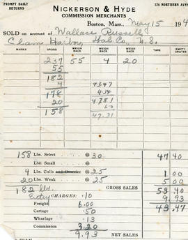
S1- Receipts and licenses
S2- Boat plans Accession number: 2013.009
Consists of records related to the life, activities, and interests of Helene Read and includes family photographs, Stoddard family history and land information, personal and professional correspondence, information about the Nova Scotia Lifeguard Service and other organizations with which Helene was involved. Accession number 2013.019
Series forms part of the Helene Read fonds and consists of a land indenture dated August 8, 1799 in which possession of land in Clam Harbour is passed from Robert, Colin, and Patrick Campbell and their wives to Thomas Stoddard. Series also includes information concerning other land grants in Clam Harbour belonging to the Campbell and Stoddard families between 1765 to 1894 and 1945. Four maps are also included in the series and include plans dated 1956 showing the division of the estate of James Stoddard as per his will, a map of the lands of Ralph Stoddard dated 1970, and two maps showing the subdivision of Lot 1 lands owned by Douglas F. Stoddard dated 1963. In addition there is one map of the land belonging to Robert Sr., Duncan, and Robert Campbell as well as two pages of microfilm copies of the land grant document presumably for that piece of land c. 1760. All maps pertain to land in Clam Harbour. Series also contains copies of the wills of James Edward Stoddard, Thomas Stoddard, Adam Stoddard, Edmund Fanning Stoddard, and documents concerning the estate of Nancy Stoddard. Accession number 2013.019
Series forms part of the Helene Read fonds and consists of one color photograph of a sandcastle (possibly taken at Clam Harbour Beach) and twenty-three black and white photographs of relatives and friends of Helene Read, as well as possible photographs of herself. Accession number 2013.019
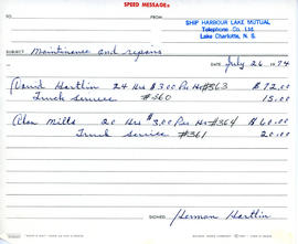
Fonds consists of records of the Ship Harbour Lake Mutual Telephone Company and includes minutes of meetings, records of telephone charges, invoices, and time sheets. Accession number 2009.039
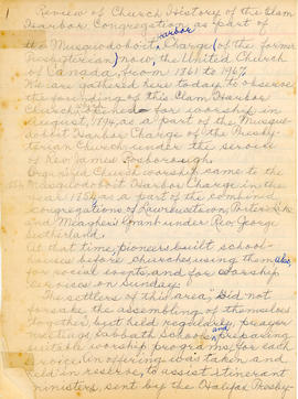
Fonds consists of records of the activities of Mrs. Stanley Robson and includes a copy of a handwritten history of the Clam Harbour United Church by Mrs. Robson, as well as an original handwritten review of the Church’s history. The texts were created in preparation for the 1967 centennial celebrations of the Church, with the review to be used as a sermon to the church’s congregation. Mrs. Robson spent two years preparing the history, and stated that she relied mostly on her memory, with the aid of records and information from other residents of the area. The review includes a brief conclusion and some annotations written in a hand other than Mrs. Robson’s. Accession number: 2010.018
Collection consists of copies of a deed, a will, and a property record related to people and places along the Eastern Shore of Nova Scotia, accumulated by the Eastern Shore Archives. Records were created in 1982.
Collection includes the 1883 will of Isaac Webber Sr. of Lakeville, an 1878 deed recording Isaac Webber’s purchase from Charlotte Garrott and Eve Parker of a parcel of land in Lakeville, and an 1850 document recording Isaac Webber’s purchase of a parcel of land between Ship Harbour and Clam Harbour. Accession number: 2008.017
Collection consists of forty monochrome aerial photographs of the Eastern Shore taken between 1931 and 1945. Also includes seven corresponding flight maps. Photographs illustrate the landscapes and coastlines of various locations along the Eastern Shore as they were in 1931-1945.
Areas covered by the aerial photographs within this collection include Owl's Head, Little Harbour, Clam Harbour, Burnt Point, Clam Bay, Lake Charlotte, Ship Harbour, Upper Lakeville, Oyster Pond, and the Jeddores. Accession number 2013.039
Series forms part of the Eastern Shore District High School fonds and consists of essays written by students pertaining to the history of different areas along the Eastern Shore. Areas included are Bayers Settlement, Chezzetcook, Clam Harbour, Gaetz Brook, Jeddore, Lake Charlotte, Upper Lakeville, Lake Echo, Little Harbour, Musquodoboit Harbour, Ostrea Lake, Petpeswick, Porters Lake, and Ship Harbour. The essays feature topics such as occupations, industries, sports, electricity, tools, education, transportation, census information, the early mail run, the general history of the area and its inhabitants as well as changes that have occurred over the years. Included in the series is the draft of the publication, The Shore Thing, which was a compilation of selected essays from the grade ten local history projects in 1974 to 1975. In addition to the essays, the publication contains jokes, recipes, puzzles and stories. There is also a photocopied picture of ice houses in Lake Banook and a photocopied article about the vessel, Fleur de Lis.
Series forms part of the Eastern Shore District High School fonds and consists of essays written by students pertaining to the history of various churches and cemeteries along the Eastern Shore. Series includes information pertaining to St. Anselm’s cemetery and Christ Church Cemetery in Chezzetcook, Clam Harbour Graveyard, the history of St. Paul’s Church in Mushaboom, St. George’s Cemetery and Ostrea Lake Anglican Church, the East Petpeswick Catholic graveyard, St. Mark’s Church in Porters Lake, and St. James Cemetery in Upper Lakeville. Some cemetery papers include lists of those who are buried there, family background information such as origin of names, lists of how many people died in given years, and hand drawn maps.