Original hand drawn map which shows the property boundaries of land to be divided between 4 sons - James, William, Wilson and John Staples - heirs of William Staples Sr. of Onslow, NS., 1871.Edward Higgins, Thomas Chisholm and Alexander Barnhill state and witness that they were asked to divide the land between the 4 sons (presumably to settle an estate). 2011.81.1
An original hand drawn map of the New Marsh, Lower Village (aka: Lower Truro, Colchester County, NS), showing numbered lots of land with owner names and acreage. Shows New Dyke Road, Soley's Creek, Cobequid Bay, Savage's Island and existing marsh area. Whole area = 51 ac, 2 qrs, 38 rods. Surveyed by Edmund Archibald, Land Surveyor, August 14, 1901. 2005.41.1
1 original hand drawn map showing new proposed road as continuation of Gunn's Road, connecting from West Branch Road to River John Road and the properties it will cross (McKay, Munroe, McBain and Langille's). Surveyed by Gilbert Sutherland Feb. 11, 1884.Confirmed - May Session, 1884. Recorded in Road Bank pgs 476-9. 2019.45.1
Original hand drawn map showing East and West Branch of French River, including a plan of Robert and Henry Oliver's Grants in the settlement of New Annan with a section of DesBarres Grant. 1999.94.35
Original hand drawn map showing Debert River, Chiganoise River, South River, Dewars River, Matatall's Brook, Mill Brook, and North River. Bruely Point (sic), churches and many small details are also shown along with dots to indicate properties and surnames of owners. 1999.94.4
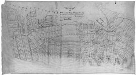
A plan of the settlement of River John and vicinity shows the area from Seafoam to Tatamagouche, including land grants and owner names as well as many details and waterways. 2017.32.1
Original hand drawn map showing Tatamagouche town lots on the property of William Campbell Esq.Includes Main Road through Tatamagouche, Road to French River, lot divisions and some surnames. 1999.94.38
Original hand drawn map showing the main road through Tatamagouche, Colchester County, NS, including the water lots and land owners: Patterson, Campbell, Purves, McCurdy, Patriquin, Williamson,and Bryelon. Also shows Road to New Annan. No surveyor nor date given. 1999.94.17
Original hand drawn map showing West Side of Waugh's River. Very light pencil (graphite) and watercolour, no names visible. Shows New Road through Tatamagouche. 1999.94.36
Original hand drawn map showing main road by shipyard of lots inlcuding William McCully and others. Includes letter to William Campbell Esq. from Robert Byers, Tatamagouche area. 1999.94.28