Original hand drawn map of "Follie Village, surveyed by me this 9th day of January 1850" by Donald Urquhart. Shows Colchester County land lots, owner names and directional measurements. Note: Map 2011.62.9 is very similar but has a few different names on the lots. Both maps were apparently done the same day by the same person. This map states, "This plan belongs to J. A. Fraser 2011.62.8
Original hand drawn map of A Plan of Lands in Folly Village, surveyed by Donald Urquhart, Dep. Sur., January 9, 1850.Shows Colchester County land lots, owner names and directional measurements. Note: Map 2011.62.8 is very similar but has a few different names on the lots. Both maps were apparently done the same day by the same person. 2011.62.9
A collection of 5 maps which include: Approaches to St. John's Harbour (1921), The North Atlantic (1919), East Coast of North America (1880), Bay of Fundy, Southern Part (1934), and St. Martins, New Brunswick and NS (1934).These maps all belonged to Captain Jonathan Borden Marsh, who was from Economy, Colchester County. 2016.14.1 to 2016.14.5
Map shows Truro Township along the Salmon River, including the first main roads of the Town. Includes grantee lots and owner names with inset of Birch Island in Upper Village. 93.40.1a
Original hand drawn map shows early downtown Truro, "Sept. 9, 1838" appears in pencil as well as "44".Shows the first streets in Truro with placement of homes and homeowner names. Includes Salmon River, Bible Hill (center), Young's Road, Mill Race, Boyd's Brook, Parade Square, Gaol, Court House, and Churches. Several items seem to have been corrected: erased and moved in the same hand - perhaps this was a work in progress. Creator unknown. 2007.107.1
Topographic map of East Folly Mountain area showing Wallace River, East Branch River, Pines Brook, Totten Brook, divided lots with owner names including Fleming, McLain, Slack, Forsyth, Patten, Crowell, Barnhill, Archibald, Duncan, McNutt and Faulkner. Drawn November 1868 by unknown person. 92.246.1
Original hand drawn map of lands belonging to the Estate of the Late Dr. William McCulloch, D.D., of Bible Hill, 1895. Includes Old Pictou Road, fence boundaries, neighboring properties, lands of Experimental Farm, buildings, and the north bank of the Salmon River. There is a red perimeter line drawn around the McCulloch estate. Drawn by W. H. Trumaine (?) E. E., Sept. 19, 1895. 2007.107.2
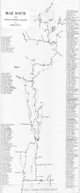
Hand drawn map showing the Mail Route from Marshall's Corner to Earltown, Colchester County in 1922-23.Includes roads and numbered dots along route which correspond to a list of home owners shown on the side of the map. Unknown creator and unknown exact date of creation. 2002.141.25
Original hand drawn map shows property of Alexander Mattatal near the North Line of Onslow Township, next to the property of A. Patterson and D. Redmond and along the road from New Annan to Truro, Colchester County, NS.Signed A. I. White, Attorney General, Nov. 26, 1883. 2001.11.1
Original hand drawn map of land grants and grantee names in part of Londonderry Township, Colchester County, NS. Includes surnames McLellan, Spencer, Denney, Dill, McLean, Skinner, and Reagh. Shows waterways and roads (unlabelled). 92.358.13