Showing 64 results

Archival description
Item · [1850]
Part of Frank Patterson Collection
Original hand drawn map showing the main road through Tatamagouche, Colchester County, NS, including the water lots and land owners: Patterson, Campbell, Purves, McCurdy, Patriquin, Williamson,and Bryelon. Also shows Road to New Annan. No surveyor nor date given. 1999.94.17
Item · 1856
Part of Frank Patterson Collection
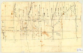
Original hand drawn map showing lands next to William Campbell in Colchester County, NS. Other lot owners include Byers, Hays, Cutten, Sutherland, Henderson, Matatall, Church Lot, Simpson, School House Lot, Morrison and McBurnie along the main road through Tatamagouche, NS. Surveyor name cut off and no date shown. 1999.94.21
Item · [1870]
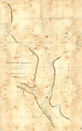
Original hand drawn map showing Tatmagouche (sic) Harbour, muddy flats dry at low tide, soundings at low water, Mingo's Wharf, Patterson's Wharf, Campbell's Saw Mill and Wharf, Bridge over the French River, New Government Wharf, Sand Point, Block House Point, Ingles Marsh. Ordinary rise of spring tides 6 feet 1 inch. No name of creator nor date. 2003.7.2
Item · 1868
Topographic map of East Folly Mountain area showing Wallace River, East Branch River, Pines Brook, Totten Brook, divided lots with owner names including Fleming, McLain, Slack, Forsyth, Patten, Crowell, Barnhill, Archibald, Duncan, McNutt and Faulkner. Drawn November 1868 by unknown person. 92.246.1
Item · 1788
Map shows Truro Township along the Salmon River, including the first main roads of the Town. Includes grantee lots and owner names with inset of Birch Island in Upper Village. 93.40.1a