Showing 38 results

Archival description
26 results with digital objects Show results with digital objects
Item · 1938
Architectural drawings of 114 Victoria Street, Truro. A Municipally Registered Heritage Property of Art Moderne style with flat roof and curved window section. Designed in 1938 by Truro architect E. D. Vernon for William H. Faltenhine, founder of the "Craftsmen" building supply store which merged with Ontario company to form Halliday Craftsmen Limited in 1923. The house is unique in the town and the drawings show the front and south elevation, ground floor and second floor plans, plan of lot, west and east elevation, basement floor plan, cross section and front of fireplace. 87.2(iii) a & b
Item · 1908
Hand drawn map showing Prince St. West - building lots and some owner names including Leaman, Bowden, Paris, Ashe, Sheppard. Surveyed for Messrs L. & Rettie by J. K. Eaton, D. C. L. Surveyor on Oct. 3, 1908. 88.69
Bay of Fundy
Item · 1863 - 1936
Bay of Fundy, Digby Gut to the Head of Navigation including bearings, heights, soundings, with insets of 8 lighthouses (illustrations), tidal information, charts, British Units, Avon River inset, CNR, Dominion Atlantic Railway, Chignecto Marine Transport railway, and towns along coastline.Surveyed by Captain P. F. Shortland, R.N., 1860, Engraved 1863 with corrections from the Canadian Government Chart of 1931 (small corrections 1933 - 1936). 88.68
Item · 1788
Map shows Truro Township along the Salmon River, including the first main roads of the Town. Includes grantee lots and owner names with inset of Birch Island in Upper Village. 93.40.1a
Item · 1901
An original hand drawn map of the New Marsh, Lower Village (aka: Lower Truro, Colchester County, NS), showing numbered lots of land with owner names and acreage. Shows New Dyke Road, Soley's Creek, Cobequid Bay, Savage's Island and existing marsh area. Whole area = 51 ac, 2 qrs, 38 rods. Surveyed by Edmund Archibald, Land Surveyor, August 14, 1901. 2005.41.1
Item · 1910
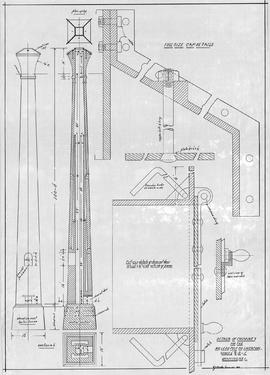
Original architectural drawing of the Details of Chimney for the McLeod Pulp Co. Ltd., Liverpool, NS.Drawing # 1, July 1910. 2019.1.11
Truro Street Map, 1900
Item · [1900]
Original hand drawn map of downtown Truro, 1900.Shows Salmon River and named streets only. 2019.7.2
Item · 1866
Map of downtown Truro showing intersection of Prince and Outram Streets with proposed subdivision of Dr. John Waddell property lying between Prince Street and the Pictou Railway line. Includes lots with measurements and some businesses. Surveyed by Isaac N. Archibald, P. D. Surveyor, County of Colchester, March 29, 1866. 2019.9.1
Item · 1900
Blueprint copy of the architectural plans of the present day Colchester Museum and Archives, once known as the Science Building of the Normal School (building next door). Original plan designed and drawn in May 1900 by Elliott & Hopson, Architects. Contractor was Charles Reid. Original drawing was redrawn in 1978 by E. Bye.Sheet 1 shows Elevation to Young Street, Cross Section and Basement Plan, 1st, 2nd and 3rd storey plans. Rooms are identified and includes some details. 2019.22.1