A 1911 newsprint reproduction of an 1837 map of Truro NS. Shows homeowner names and buildings, businesses, main roads, Salmon River, Mill Race and Boyd's Brook. 88.92
Reproduction map created by the Department of Marine and Fisheries in 1913, showing lighthouses, fog signals, wireless stations, life saving stations, buoys, list of radio-telegraph coast stations for communications with ships, marine species identified and a legend for minerals. 88.52
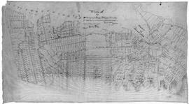
One black and white reproduction map created by D. D. Currie of Moncton in 1889. Shows hand illustrated streets, homes and large buildings throughout the Town of Truro and includes detailed labelled drawings of major businesses around the outer edge of the map. 94.137.1
Color reproduction map of the Town of Pictou, NS, 1878. Published by J. H. Meachan & Co, and C. R. Allen (surveyor). Was originally folded and likely accompanied an Atlas Book of Pictou County. Shows Town of Pictou including 1st, 2nd and 3rd Wards, streets, buildings, lots and owner names, Pictou Harbour and wharves plus many other details. 2007.25.7
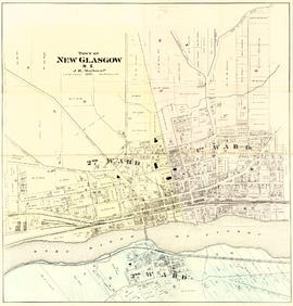
Color reproduction map of the Town of New Glasgow, NS, 1878. Published by J. H. Meachan & Co, and C. R. Allen (surveyor). Was originally folded and likely accompanied an Atlas Book of Pictou County. Shows Town of New Glasgow including 1st, 2nd and 3rd Wards, streets, buildings, lots and owner names, East River of Pictou and many other details. 2007.25.7a
A reproduction map of Atlantic Canada showing a list of wreck sites and their locations. Showing coastal towns, cities, provinces, main waterways, inset of Halifax Harbour. Published by the hydrographic and Map Service, Survey`s and Engineering Branch, Dept, of Mines and Resources, Ottawa. First Edition 1943, New edition Dec. 15, 1944. 2007.89.1
Plan of location for Board Landing Bridge over the Salmon River, Colchester Co., NS. Shows the bank of the river and creek flowing into same on the south west side of the bridge. Distance about 3 miles from Truro, on the Parrsboro/Amherst highway. Unknown creator and date. 2012.17.8
Truro Township map showing grantees and lots as drawn by Thomas Harris in 1788.This is a "true copy" of the original as stated on the map. 2013.60.4a+b
A plan of the settlement of River John and vicinity shows the area from Seafoam to Tatamagouche, including land grants and owner names as well as many details and waterways. 2017.32.1