Original hand drawn map which shows the property boundaries of land to be divided between 4 sons - James, William, Wilson and John Staples - heirs of William Staples Sr. of Onslow, NS., 1871.Edward Higgins, Thomas Chisholm and Alexander Barnhill state and witness that they were asked to divide the land between the 4 sons (presumably to settle an estate). 2011.81.1
An original plan of building lots in Acadian (Acadia) Mines, Colchester County, NS, on lands belonging to the late Robert Forman Esq.Shows roads, lots, some adjacent property owners. Family tree of direct descendants is available on CHS Map Data Worksheet.Hand drawn "copy" by S.G.A. Morrison, May 17, 1888, Lornedale, NS 2016.96.1
A plan of the settlement of River John and vicinity shows the area from Seafoam to Tatamagouche, including land grants and owner names as well as many details and waterways. 2017.32.1
Original hand drawn map which shows the topographical junction point of Colchester, Halifax and Guysborough Counties. This is an early, undated map, but since Guysborough was officially named in 1836, we know this map to be later than this date, but likely no later than 1875. The map shows land grants and grantee names, waterways and roads. Of note is Windsor College marked on 5 acres. 2019.24.1
Original hand drawn map of the Back Lots of the Township of Truro, NS. Copied by Isreal Longworth March 7, 1858. Includes land grants and names of property owners, some roads, marshlands and waterways. 2019.38.1
1 original hand drawn map showing new proposed road as continuation of Gunn's Road, connecting from West Branch Road to River John Road and the properties it will cross (McKay, Munroe, McBain and Langille's). Surveyed by Gilbert Sutherland Feb. 11, 1884.Confirmed - May Session, 1884. Recorded in Road Bank pgs 476-9. 2019.45.1
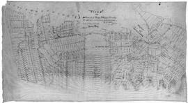
Original hand drawn map of downtown Truro, 1900, labelled with red dots to indicate present location of arc street lights - 48 in all. Red circles indicate I.C.R. (Intercolonial Railway) lights. Shows Salmon River and part of the railway through Truro. 2019.7.1
Topographic map of East Folly Mountain area showing Wallace River, East Branch River, Pines Brook, Totten Brook, divided lots with owner names including Fleming, McLain, Slack, Forsyth, Patten, Crowell, Barnhill, Archibald, Duncan, McNutt and Faulkner. Drawn November 1868 by unknown person. 92.246.1
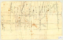
Original hand drawn map of land grants and grantee names in part of Londonderry Township, Colchester County, NS. Includes surnames McLellan, Spencer, Denney, Dill, McLean, Skinner, and Reagh. Shows waterways and roads (unlabelled). 92.358.13