Showing 63 results

Archival description
Item · 1908
Part of George Mosher Collection
Original architectural drawing for a Boiler Setting for the Kent Lumber Co. including vertical cross sections and end elevation with measurements and building details. Kent Lumber Co. operated in Colchester County, NS. 2019.1.8
Item · 1895
Original hand drawn map of lands belonging to the Estate of the Late Dr. William McCulloch, D.D., of Bible Hill, 1895. Includes Old Pictou Road, fence boundaries, neighboring properties, lands of Experimental Farm, buildings, and the north bank of the Salmon River. There is a red perimeter line drawn around the McCulloch estate. Drawn by W. H. Trumaine (?) E. E., Sept. 19, 1895. 2007.107.2
Item · 1922
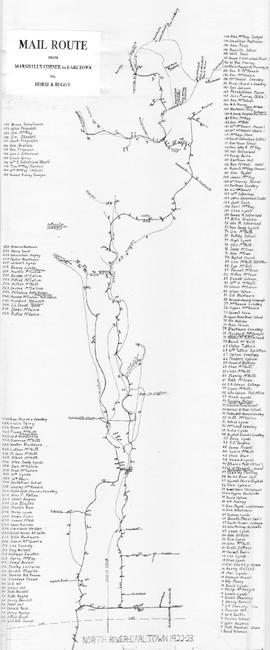
Hand drawn map showing the Mail Route from Marshall's Corner to Earltown, Colchester County in 1922-23.Includes roads and numbered dots along route which correspond to a list of home owners shown on the side of the map. Unknown creator and unknown exact date of creation. 2002.141.25
Item · 1883
Original hand drawn map shows property of Alexander Mattatal near the North Line of Onslow Township, next to the property of A. Patterson and D. Redmond and along the road from New Annan to Truro, Colchester County, NS.Signed A. I. White, Attorney General, Nov. 26, 1883. 2001.11.1
Item · 1856
Part of Frank Patterson Collection
Original hand drawn map showing lands next to William Campbell in Colchester County, NS. Other lot owners include Byers, Hays, Cutten, Sutherland, Henderson, Matatall, Church Lot, Simpson, School House Lot, Morrison and McBurnie along the main road through Tatamagouche, NS. Surveyor name cut off and no date shown. 1999.94.21