Original hand drawn map shows property of Alexander Mattatal near the North Line of Onslow Township, next to the property of A. Patterson and D. Redmond and along the road from New Annan to Truro, Colchester County, NS.Signed A. I. White, Attorney General, Nov. 26, 1883. 2001.11.1
Fonds consists of seven bound fire-insurance maps relating to Mahone Bay, one of which dates from 1922; whereas the other six (revised versions of 1934 maps) date from 1947. The maps, which were created by the Underwriters Survey Bureau Ltd. and issued under the auspices of the Nova Scotia Board of Fire Insurers, were likely obtained by Joudrey in his capacity as Mahone Bay’s Town Clerk. MBMS-57
Original hand drawn map of land grants and grantee names in part of Londonderry Township, Colchester County, NS. Includes surnames McLellan, Spencer, Denney, Dill, McLean, Skinner, and Reagh. Shows waterways and roads (unlabelled). 92.358.13
An original hand drawn map which states, "I certify that this plan is a true and correct copy of a Plan of the Partitions of the Township of Londonderry filed in this office. Dept. of Crown Lands, 12 Feby 1861, Samuel P. Fairbanks, Comm. Crown Lands.Includes granted lands, names of lot owners and acreage. 2011.62.10
Consists of a hydrographic map of the North Atlantic Ocean. Recorded observations (Notices to Mariners) of October 1888 indicated in red print include hurricane paths and dates, ship wreaks, fog belts, icebergs, general drift of ocean currents and prevailing winds (blue print) among other details. Forecasts for November 1888.This map belonged to Capt. John Congdon of Great Village, NS. He was the Master of the ship "Bedford". 90.77.3
An original plan of building lots in Acadian (Acadia) Mines, Colchester County, NS, on lands belonging to the late Robert Forman Esq.Shows roads, lots, some adjacent property owners. Family tree of direct descendants is available on CHS Map Data Worksheet.Hand drawn "copy" by S.G.A. Morrison, May 17, 1888, Lornedale, NS 2016.96.1
Original hand drawn map showing Tatamagouche and Area - DesBarres Grant lots and others. Showing county lines, lots, owners, waterways. Dates 1853 - 1867. Surveyed by George Hattie, Land Surveyor 2003.7.1
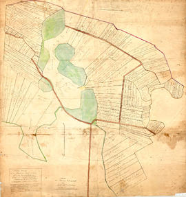
Original map showing Masstown Marsh including roads, waterways and granted lots with grantee names and acreages.Coloured: green indicates upland and islands, yellow indicates drains, creeks and ponds, brown indicates roads, red indicates dykes.Made by Thos. Miller, Surveyor, on July 25, 1863. Copy made for made for James Campbell by A. W. McLelan on September 12, 1863. 92.358.28
Original hand drawn map which shows the property boundaries of land to be divided between 4 sons - James, William, Wilson and John Staples - heirs of William Staples Sr. of Onslow, NS., 1871.Edward Higgins, Thomas Chisholm and Alexander Barnhill state and witness that they were asked to divide the land between the 4 sons (presumably to settle an estate). 2011.81.1
An original hand drawn map of the New Marsh, Lower Village (aka: Lower Truro, Colchester County, NS), showing numbered lots of land with owner names and acreage. Shows New Dyke Road, Soley's Creek, Cobequid Bay, Savage's Island and existing marsh area. Whole area = 51 ac, 2 qrs, 38 rods. Surveyed by Edmund Archibald, Land Surveyor, August 14, 1901. 2005.41.1