Showing 36 results

Archival description
24 results with digital objects Show results with digital objects
Item · 1858
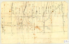
Original hand drawn map of the Back Lots of the Township of Truro, NS. Copied by Isreal Longworth March 7, 1858. Includes land grants and names of property owners, some roads, marshlands and waterways. 2019.38.1
Item · 1884
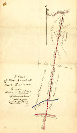
1 original hand drawn map showing new proposed road as continuation of Gunn's Road, connecting from West Branch Road to River John Road and the properties it will cross (McKay, Munroe, McBain and Langille's). Surveyed by Gilbert Sutherland Feb. 11, 1884.Confirmed - May Session, 1884. Recorded in Road Bank pgs 476-9. 2019.45.1
Item · 1900
Original hand drawn map of downtown Truro, 1900, labelled with red dots to indicate present location of arc street lights - 48 in all. Red circles indicate I.C.R. (Intercolonial Railway) lights. Shows Salmon River and part of the railway through Truro. 2019.7.1
Truro Street Map, 1900
Item · [1900]
Original hand drawn map of downtown Truro, 1900.Shows Salmon River and named streets only. 2019.7.2
Frank W. Jordan fonds
Fonds · 1885-2002, predominant 1930s-1970s
Fonds consists of personal, business, association and institutional records relating to the Municipality of the District of St. Mary’s, with a special emphasis on Sherbrooke, Nova Scotia. Included are meeting minutes, reports, and news from local associations including Heritage Goldenville Society, Royal Canadian Legion, Queen’s Lodge No. 34 A. F. & A. M., Sherbrooke Amateur Athletic Association, Sherbrooke Hockey League, St. Mary’s Boat Club, St. Mary’s Curling Club, St. Mary’s Driving Society, St. Mary’s Guest Home Society, St. Mary’s Historical Society, St. Mary’s District Rink Association and RecPlex, St. Mary’s River Association (1924-2003, predominantly 1970s-early 2000s); correspondence from the Department of Fisheries (c. 1920s); news clippings, reports, and press releases for local events including Communities in Bloom and Old Fashioned Christmas at Sherbrooke Village (1945-2002, predominantly early 2000s); maps, budgets, reports, meeting minutes, and other paperwork from Historic Sherbrooke Village (1971-1977); ledgers, news clippings, pulp samples from a local mill, and other papers related to local merchants and industry in the region (1872-2001, predominantly 1948-1968); papers from the Presbyterian, United, and St. James Anglican Churches, as well as the St. Mary’s Municipal School Board, Post Office, Library, St. Mary’s District Lions Club, St. Mary’s Memorial Hospital, Sunset Rest Cemetery, Down East Fire Fighters Association and Fire Department (1915-1996, predominantly 1930s-2000s); newspapers with Sherbrooke-related content, including the Family Herald and Weekly Star (1948), The Eastern Chronicle (1919), and Canso Breeze (1965-1966); a diary, family photographs, horse racing album, military service records, business ledgers, and personal family papers of Frank Jordan himself alongside unpublished memoirs and other papers from other Sherbrooke residents on the subject of local history; photographs, personal accounts, and newsletters about the St. Mary’s River (1900-2002, primarily concerning the 1956 flood). Also included in the collection are oral histories recorded at meetings of the St. Mary’s Historical Society (1978-1990). Fonds consists of the following series:Series 1: Andersons and Murdochs, Collected PapersSeries 2: Associations, LocalSeries 3: Department of FisheriesSeries 4: Diary (Digitized)Series 5: Emergency Measures OrganizationSeries 6: Events, LocalSeries 7: Historic Sherbrooke VillageSeries 8: Horse Racing Album (Digitized)Series 9: Business, LocalSeries 10: Institutions, LocalSeries 11: Municipality of the District of St. Mary’sSeries 12: Newspapers, RegionalSeries 13: Oral HistoriesSeries 14: Papers, CollectedSeries 15: Photographs (Digitized)Series 16: Periodicals, Collected RegionalSeries 17: St. Mary’s District Development AssociationSeries 18: St. Mary’s Historical Society and Historical MaterialSeries 19: St. Mary’s River 2020.011
Fonds · 1783-2006
Fonds gathers material about the history of Loyalists in Guysborough County, N.S., from their arrival in 1783, as well as the activities of the Country Harbour Loyalist Society, notably their 1983 re-enactment of the Landing of the Loyalists and the 2006 grand opening of the Municipal Park and Loyalist Walking Trail in Stormont, Country Harbour. Fonds includes papers generated by the operation of the society, including paperwork for the incorporation of the society, meeting minutes, event planning notes, and letters of support from the community. Fonds consists of the following series:Series 1: Parks CanadaSeries 2: HistorySeries 3: Legal Society BusinessSeries 4: Re-Enactment PhotographsSeries 5: Guysborough County Heritage AssociationSeries 6: Minutes of the Country Harbour Loyalist SocietySeries 7: The Loyalist TrailSeries 8: Form Letters of SupportSeries 9: Volunteer Involvement 2021.029
Lomas family fonds
Fonds · 1866- 2009, predominant 1970- 2000
Fonds consists of collected research on the history of the Municipality of the District of St. Mary’s from its earliest records, with a special focus on gold mining and Goldenville, Nova Scotia, as well as the personal archives of the Lomas family recording their decades of public service alongside historical material gathered from their families and the community in Sherbrooke, Nova Scotia. The historical research begins with the earliest inhabitants of the Municipality of the District of St. Mary’s, and continues with the arrival of Europeans, reports on the economic development of the area, essays on regional occupations, churches, charitable organizations, schools, government, transportation, communications, energy, banking, health care, recreation, and the war effort in two world wars. It collects research on the communities of Ecum Secum, Marie Joseph, New Chester, The Liscombs, Spanish Ship Bay, Sherbrooke, Sonora, Wine Harbour, Indian Harbour, Port Hilford, Port Bickerton, Harpelville, Fisherman’s Harbour, Jordanville, Stillwater, Waternish, Melrose, Aspen, The Forks, Denver, Glenelg, Smithfield, the Caledonias, Goshen, Argyle, Garden of Eden and the St. Mary’s River. Goldenville, Nova Scotia, is covered extensively with maps, photographs, census reports and other papers. Many histories of the region are collected in this fond, including unpublished memoirs. Papers from the Prince Henry Sinclair Society, St. Mary’s Historical Society, West River Station Restoration Committee, St. Mary’s Anglican Church in Summerside, Prince Edward Island, Sherbrooke Library, Sherbrooke Village, Canso Historical Society, and the Liberal Party of Nova Scotia are also in this fonds, alongside a generous collection of material generated by the Lomas family themselves. There are records from the foreign service of Alton Anderson Lomas in the United States, Mexico, Belgium, and China, as well as his political work in Ontario and Nova Scotia. There is also an extensive record of the community service done by Al and Aleah Lomas, notably her work as librarian at the Sherbrooke Library, and several awards for volunteer service. In addition to the Lomas family material, this fonds holds genealogy research for many local families, notably the McKean/McKeen, Anderson, Henderson, Landesberg, and McLane families. There are photographs of local people and landscapes dating back to the 1870 opening of the first bridge over the St. Mary’s River at Sherbrooke, up to the 2005 wedding reception of Aleah Lomas Anderson and Murray Anderson, with an emphasis on the Anderson, Lomas, Palmer, and MacDonald families. The fonds also has audio and video recordings of interviews, speeches, and brief reports discussing topics of interest to the eastern shore of Nova Scotia. Fonds consists of the following series:Series 1: History of the Municipality of the District of St. Mary’sSeries 2: Lomas History of the Municipality of the District of St. Mary’sSeries 3: St. Mary’s Historical SocietySeries 4: CemeteriesSeries 5: ChurchesSeries 6: Foreign ServicesSeries 7: GenealogySeries 8: Gold Mining and Heritage Goldenville SocietySeries 9: Heritage / Heritage Inventory ProgramSeries 10: Industry, LocalSeries 11: MapsSeries 12: MemoirsSeries 13: MilitarySeries 14: News ClippingsSeries 15: ObituariesSeries 16: Personal PapersSeries 17: PhotographsSeries 18: Photographic SlidesSeries 19: Sherbrooke LibrarySeries 20: Sherbrooke VillageSeries 21: Audio RecordingsSeries 22: VHS cassette tapesSeries 23: Ships and shippingSeries 24: Books and Periodicals, CollectedSeries 25: MacDonald familySeries 26: Glass negativesSeries 27: Canadian Government ServiceSeries 28: Community Initiatives 2022.006
Bay of Fundy
Item · 1863 - 1936
Bay of Fundy, Digby Gut to the Head of Navigation including bearings, heights, soundings, with insets of 8 lighthouses (illustrations), tidal information, charts, British Units, Avon River inset, CNR, Dominion Atlantic Railway, Chignecto Marine Transport railway, and towns along coastline.Surveyed by Captain P. F. Shortland, R.N., 1860, Engraved 1863 with corrections from the Canadian Government Chart of 1931 (small corrections 1933 - 1936). 88.68
Item · 1888
Consists of a hydrographic map of the North Atlantic Ocean. Recorded observations (Notices to Mariners) of October 1888 indicated in red print include hurricane paths and dates, ship wreaks, fog belts, icebergs, general drift of ocean currents and prevailing winds (blue print) among other details. Forecasts for November 1888.This map belonged to Capt. John Congdon of Great Village, NS. He was the Master of the ship "Bedford". 90.77.3
Item · 1868
Topographic map of East Folly Mountain area showing Wallace River, East Branch River, Pines Brook, Totten Brook, divided lots with owner names including Fleming, McLain, Slack, Forsyth, Patten, Crowell, Barnhill, Archibald, Duncan, McNutt and Faulkner. Drawn November 1868 by unknown person. 92.246.1