This history is a discrete item and was written by Clare Palmer in 1938 when she was about thirteen years old. It was likely part of a school assignment as there appears to be a comment written by the teacher on the last page. In his or her comment the teacher praises the value of the information provided by Clare and suggests that she donate it to the public archives. This handwritten, handmade history book is based on information provided by Mr. George Marks, Mrs. Bruce Marks, and Mr. and Mrs. E. A. Marks, whose contribution is acknowledged by Clare at the outset of her work. Her history includes chapters on the first settlers, the growth of the settlement, Ship Harbour industries, schools, transportation, churches, food, clothing, and lights; amusements, public buildings, prominent people, nature, and a final chapter that discusses Nichol Island and Wolfe Point as well as the origin of the name “Ship Harbour.” The book includes three hand drawn maps: one of Ship Harbour that features dwellings, G. L Monk’s store and mill, the J. L. factory, and the chapel; a second map depicting early roads in the area in 1863 as well as a ferry; and one small map of Nichol Island. The second last page also includes a photograph of the lighthouse at Wolfe Point on Nichol Island, which is were Clare lived with her family in the lightkeeper’s house. The book also includes two newspaper clippings, one about Daniel Weeks and one about the 50th anniversary of Mr. and Mrs. Edward Addington Marks which includes a picture. Accession number: 2013.013
Fonds consists of collected research on the history of the Municipality of the District of St. Mary’s from its earliest records, with a special focus on gold mining and Goldenville, Nova Scotia, as well as the personal archives of the Lomas family recording their decades of public service alongside historical material gathered from their families and the community in Sherbrooke, Nova Scotia.
The historical research begins with the earliest inhabitants of the Municipality of the District of St. Mary’s, and continues with the arrival of Europeans, reports on the economic development of the area, essays on regional occupations, churches, charitable organizations, schools, government, transportation, communications, energy, banking, health care, recreation, and the war effort in two world wars. It collects research on the communities of Ecum Secum, Marie Joseph, New Chester, The Liscombs, Spanish Ship Bay, Sherbrooke, Sonora, Wine Harbour, Indian Harbour, Port Hilford, Port Bickerton, Harpelville, Fisherman’s Harbour, Jordanville, Stillwater, Waternish, Melrose, Aspen, The Forks, Denver, Glenelg, Smithfield, the Caledonias, Goshen, Argyle, Garden of Eden and the St. Mary’s River. Goldenville, Nova Scotia, is covered extensively with maps, photographs, census reports and other papers. Many histories of the region are collected in this fond, including unpublished memoirs.
Papers from the Prince Henry Sinclair Society, St. Mary’s Historical Society, West River Station Restoration Committee, St. Mary’s Anglican Church in Summerside, Prince Edward Island, Sherbrooke Library, Sherbrooke Village, Canso Historical Society, and the Liberal Party of Nova Scotia are also in this fonds, alongside a generous collection of material generated by the Lomas family themselves. There are records from the foreign service of Alton Anderson Lomas in the United States, Mexico, Belgium, and China, as well as his political work in Ontario and Nova Scotia. There is also an extensive record of the community service done by Al and Aleah Lomas, notably her work as librarian at the Sherbrooke Library, and several awards for volunteer service.
In addition to the Lomas family material, this fonds holds genealogy research for many local families, notably the McKean/McKeen, Anderson, Henderson, Landesberg, and McLane families. There are photographs of local people and landscapes dating back to the 1870 opening of the first bridge over the St. Mary’s River at Sherbrooke, up to the 2005 wedding reception of Aleah Lomas Anderson and Murray Anderson, with an emphasis on the Anderson, Lomas, Palmer, and MacDonald families. The fonds also has audio and video recordings of interviews, speeches, and brief reports discussing topics of interest to the eastern shore of Nova Scotia.
Fonds consists of the following series:Series 1: History of the Municipality of the District of St. Mary’sSeries 2: Lomas History of the Municipality of the District of St. Mary’sSeries 3: St. Mary’s Historical SocietySeries 4: CemeteriesSeries 5: ChurchesSeries 6: Foreign ServicesSeries 7: GenealogySeries 8: Gold Mining and Heritage Goldenville SocietySeries 9: Heritage / Heritage Inventory ProgramSeries 10: Industry, LocalSeries 11: MapsSeries 12: MemoirsSeries 13: MilitarySeries 14: News ClippingsSeries 15: ObituariesSeries 16: Personal PapersSeries 17: PhotographsSeries 18: Photographic SlidesSeries 19: Sherbrooke LibrarySeries 20: Sherbrooke VillageSeries 21: Audio RecordingsSeries 22: VHS cassette tapesSeries 23: Ships and shippingSeries 24: Books and Periodicals, CollectedSeries 25: MacDonald familySeries 26: Glass negativesSeries 27: Canadian Government ServiceSeries 28: Community Initiatives 2022.006
Londonderry Township map showing Planter Grantees and Lots. Traced from original by James Fulton, D. Surveyor, abt. 1780. Downscaled tracing done by Bruce McNutt, 1983. 2019.19.1
Original hand drawn map of Mill Brook, Colchester County. Granted lots near border of western side of DesBarres Grant including family names: Halliday, George, Swan, Clark, Pugh, Oliver. Stamped with a seal visible on paper - appears to belong with a land grant for James Clark.Surveyed by John Spry Morris, Surveyor General, Halifax, Oct. 11, 1845. 88.14
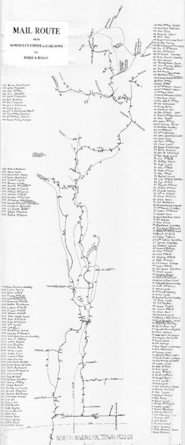
Hand drawn map showing the Mail Route from Marshall's Corner to Earltown, Colchester County in 1922-23.Includes roads and numbered dots along route which correspond to a list of home owners shown on the side of the map. Unknown creator and unknown exact date of creation. 2002.141.25
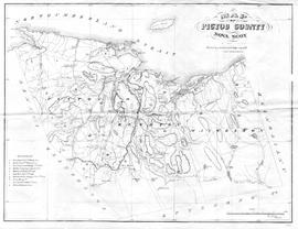
Map showing Pictou County mining areas including Nova Scotia Coal Co., Acadia Coal Co., Intercolonial Coal Mining Co., Halifax Company, Montreal & Pictou Co., East River Coal Co., Montreal & New Glasgow Coal Co., Pictou Mining Co., Vale Coal Iron & Mfg Co., and Mitchell & Barton's area. Undated, but research revealed Montreal & New Glasgow Colliery opened at Coal Brook and operated for one year only - 1868, therefore its inclusion on this map seems to date it closely to this time period. See novascotia.ca/archives/meninmines/timeline. Drawn by George Hattie, Land Surveyor. Printed by Barlan Desbarats Litho. Company, Montreal. 2019.5.1
Original hand drawn map showing Plan to Colchester County Line including lots of grantees Patterson, Campbell, Graham, Rev. William and many others. DesBarres Grant area. 1999.94.30
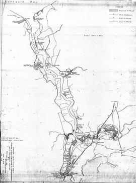
Copy of map drawn by H. Linneborn, Feb. 20, 1956. Map shows marsh locations along the Cobequid Bay & Minas Basin including roads, highways, trails, waterways, towns, railways and a legend. 2013.60.6A
Copy of map drawn by H. Linneborn, Feb. 28, 1956. Map shows marsh locations along the Shubenacadie and Stewiacke Rivers in both Hants and Colchester County, NS. Includes roads, highways, trails, waterways, towns, railways and a legend. 2013.60.6B
Collection consists of forty monochrome aerial photographs of the Eastern Shore taken between 1931 and 1945. Also includes seven corresponding flight maps. Photographs illustrate the landscapes and coastlines of various locations along the Eastern Shore as they were in 1931-1945.
Areas covered by the aerial photographs within this collection include Owl's Head, Little Harbour, Clam Harbour, Burnt Point, Clam Bay, Lake Charlotte, Ship Harbour, Upper Lakeville, Oyster Pond, and the Jeddores. Accession number 2013.039