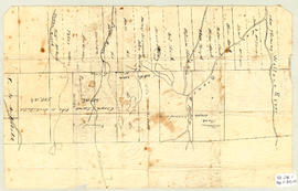
Topographic map of East Folly Mountain area showing Wallace River, East Branch River, Pines Brook, Totten Brook, divided lots with owner names including Fleming, McLain, Slack, Forsyth, Patten, Crowell, Barnhill, Archibald, Duncan, McNutt and Faulkner. Drawn November 1868 by unknown person. 92.246.1
Original hand drawn map with letter showing land granted to Abraham Patterson and John & Robert Cock, including road to Farm Lake Mills in the DesBarres Grant area. 1999.94.22
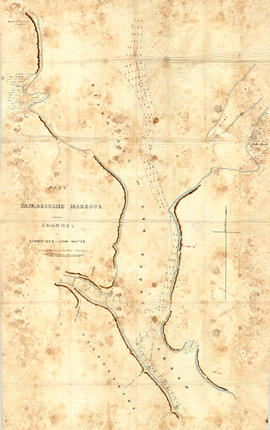
Original hand drawn map showing Tatmagouche (sic) Harbour, muddy flats dry at low tide, soundings at low water, Mingo's Wharf, Patterson's Wharf, Campbell's Saw Mill and Wharf, Bridge over the French River, New Government Wharf, Sand Point, Block House Point, Ingles Marsh. Ordinary rise of spring tides 6 feet 1 inch. No name of creator nor date. 2003.7.2
Original hand drawn map which shows the property boundaries of land to be divided between 4 sons - James, William, Wilson and John Staples - heirs of William Staples Sr. of Onslow, NS., 1871.Edward Higgins, Thomas Chisholm and Alexander Barnhill state and witness that they were asked to divide the land between the 4 sons (presumably to settle an estate). 2011.81.1
The fonds consists of assorted records created by the Town of Truro, including annual reports, Sinking Fund Investments, assessment rolls (380 cm), school board records, nomination papers, for a century from 1886 - 1988. The fonds has had accruals since the initial acquisitions in 1999. The Victoria Park record series contains maps, ephemera, reports, minutes, financial statements, correspondence, and plans for the park; this series has had accruals. 2003.19.1 - 207
Original hand drawn map showing west side of Waugh's River, high water mark, properties of heirs of late William Campbell Esq.. Also shows Main Road through Tatamagouche and other town lots. 1999.94.29
A collection of 5 maps which include: Approaches to St. John's Harbour (1921), The North Atlantic (1919), East Coast of North America (1880), Bay of Fundy, Southern Part (1934), and St. Martins, New Brunswick and NS (1934).These maps all belonged to Captain Jonathan Borden Marsh, who was from Economy, Colchester County. 2016.14.1 to 2016.14.5
Original hand drawn map shows property of Alexander Mattatal near the North Line of Onslow Township, next to the property of A. Patterson and D. Redmond and along the road from New Annan to Truro, Colchester County, NS.Signed A. I. White, Attorney General, Nov. 26, 1883. 2001.11.1
1 original hand drawn map showing new proposed road as continuation of Gunn's Road, connecting from West Branch Road to River John Road and the properties it will cross (McKay, Munroe, McBain and Langille's). Surveyed by Gilbert Sutherland Feb. 11, 1884.Confirmed - May Session, 1884. Recorded in Road Bank pgs 476-9. 2019.45.1
Fonds consists primarily of Florence Jessie Murray's personal records regarding her career as a medical missionary in Korea, including correspondence, manuscripts, pamphlets and photographs. There is also a small volume of records that originated with her brother, Alexander Murray, and father, Robert Murray, including correspondence between Alexander Murray, Florence Jessie Murray and E.J.O. Fraser; Reverend Robert Murray's correspondence; and records regarding his involvement with the Navy, Army and Air Force Institutes. MS-2-535