Original hand drawn map which shows the property boundaries of land to be divided between 4 sons - James, William, Wilson and John Staples - heirs of William Staples Sr. of Onslow, NS., 1871.Edward Higgins, Thomas Chisholm and Alexander Barnhill state and witness that they were asked to divide the land between the 4 sons (presumably to settle an estate). 2011.81.1
Original reproduction certificate issued to J. L. Peppard. Certifies that, "...he having expressed a desire to withdraw from the Lodge, is fully paid and has complied with the requirements, his leave is therefore granted." Signed at Truro, October 14, 1872. 2019.20.1
Original reproduction certificate issued to J. L. Peppard. Certifies that he "...is raised to Degree of Master Mason in the Lodge Cobequid No. 37. Given at Masonic Hall, Halifax this 10th day of February in the year of our Lord 1872 and of Light 5872." English text is displayed on the left hand side of the certificate - Latin translation is on the right. 2019.20.2
Street map of 1878 Truro and Bible Hill including names on many properties and a separate list of names and businesses identified. Shows railway, buildings and Salmon River. Very detailed and could be a mate to the A. F. Church Co. map series, but this is not confirmed. Appears very similar. 88.20
Original hand drawn map showing west side of Waugh's River, high water mark, properties of heirs of late William Campbell Esq.. Also shows Main Road through Tatamagouche and other town lots. 1999.94.29
Color reproduction map of the Town of Pictou, NS, 1878. Published by J. H. Meachan & Co, and C. R. Allen (surveyor). Was originally folded and likely accompanied an Atlas Book of Pictou County. Shows Town of Pictou including 1st, 2nd and 3rd Wards, streets, buildings, lots and owner names, Pictou Harbour and wharves plus many other details. 2007.25.7
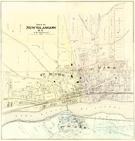
Color reproduction map of the Town of New Glasgow, NS, 1878. Published by J. H. Meachan & Co, and C. R. Allen (surveyor). Was originally folded and likely accompanied an Atlas Book of Pictou County. Shows Town of New Glasgow including 1st, 2nd and 3rd Wards, streets, buildings, lots and owner names, East River of Pictou and many other details. 2007.25.7a
Item is a photograph of a view of the summit of Salt Hill taken by Theodore Keisel, photographer, who came to Baddeck to visit Alexander Graham Bell in 1889 or 1890. 78-731-2481