Showing 78 results

Archival description
64 results with digital objects Show results with digital objects
Item · 1850
Original hand drawn map of A Plan of Lands in Folly Village, surveyed by Donald Urquhart, Dep. Sur., January 9, 1850.Shows Colchester County land lots, owner names and directional measurements. Note: Map 2011.62.8 is very similar but has a few different names on the lots. Both maps were apparently done the same day by the same person. 2011.62.9
Item · 1871
Original hand drawn map which shows the property boundaries of land to be divided between 4 sons - James, William, Wilson and John Staples - heirs of William Staples Sr. of Onslow, NS., 1871.Edward Higgins, Thomas Chisholm and Alexander Barnhill state and witness that they were asked to divide the land between the 4 sons (presumably to settle an estate). 2011.81.1
Frank Fulton Collection
Collection · 1896 - 1973
The fonds consists of materials related to the history of Truro and Colchester County, NS that were collected by Frank Fulton throughout his lifetime, including directories, scrapbooks, books. The collection of 118 photographs show the Fulton family's activities during World War II, including images taken overseas. They also show the family spending time at Spencer's Point, NS; Big Cove Camp and Melmerby Beach, Pictou County, NS; businesses around Truro, NS during the 1970s; Frank's ironworks collection; and several postcards of scenes around Truro. 2012.6.1 - 46
Collection · 1934
A collection of 5 maps which include: Approaches to St. John's Harbour (1921), The North Atlantic (1919), East Coast of North America (1880), Bay of Fundy, Southern Part (1934), and St. Martins, New Brunswick and NS (1934).These maps all belonged to Captain Jonathan Borden Marsh, who was from Economy, Colchester County. 2016.14.1 to 2016.14.5
Item · 1888
An original plan of building lots in Acadian (Acadia) Mines, Colchester County, NS, on lands belonging to the late Robert Forman Esq.Shows roads, lots, some adjacent property owners. Family tree of direct descendants is available on CHS Map Data Worksheet.Hand drawn "copy" by S.G.A. Morrison, May 17, 1888, Lornedale, NS 2016.96.1
Item · [after 1836]
Original hand drawn map which shows the topographical junction point of Colchester, Halifax and Guysborough Counties. This is an early, undated map, but since Guysborough was officially named in 1836, we know this map to be later than this date, but likely no later than 1875. The map shows land grants and grantee names, waterways and roads. Of note is Windsor College marked on 5 acres. 2019.24.1
Item · 1858
Original hand drawn map of the Back Lots of the Township of Truro, NS. Copied by Isreal Longworth March 7, 1858. Includes land grants and names of property owners, some roads, marshlands and waterways. 2019.38.1
Item · 1884
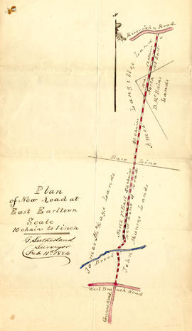
1 original hand drawn map showing new proposed road as continuation of Gunn's Road, connecting from West Branch Road to River John Road and the properties it will cross (McKay, Munroe, McBain and Langille's). Surveyed by Gilbert Sutherland Feb. 11, 1884.Confirmed - May Session, 1884. Recorded in Road Bank pgs 476-9. 2019.45.1
Item · 1900
Original hand drawn map of downtown Truro, 1900, labelled with red dots to indicate present location of arc street lights - 48 in all. Red circles indicate I.C.R. (Intercolonial Railway) lights. Shows Salmon River and part of the railway through Truro. 2019.7.1
Truro Street Map, 1900
Item · [1900]
Original hand drawn map of downtown Truro, 1900.Shows Salmon River and named streets only. 2019.7.2