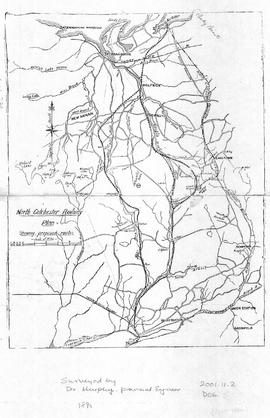
Map of North Colchester County, NS, showing proposed railway plan. Also includes existing Intercolonial Railway, Pictou Branch, Short Line through Tatamagouche, county towns, some waterways and roads. Surveyed by D. Murphy, Provincial Engineer, 1890. 2001.11.2
An original hand drawn map of the New Marsh, Lower Village (aka: Lower Truro, Colchester County, NS), showing numbered lots of land with owner names and acreage. Shows New Dyke Road, Soley's Creek, Cobequid Bay, Savage's Island and existing marsh area. Whole area = 51 ac, 2 qrs, 38 rods. Surveyed by Edmund Archibald, Land Surveyor, August 14, 1901. 2005.41.1
Original hand drawn map shows early downtown Truro, "Sept. 9, 1838" appears in pencil as well as "44".Shows the first streets in Truro with placement of homes and homeowner names. Includes Salmon River, Bible Hill (center), Young's Road, Mill Race, Boyd's Brook, Parade Square, Gaol, Court House, and Churches. Several items seem to have been corrected: erased and moved in the same hand - perhaps this was a work in progress. Creator unknown. 2007.107.1
Original hand drawn map of lands belonging to the Estate of the Late Dr. William McCulloch, D.D., of Bible Hill, 1895. Includes Old Pictou Road, fence boundaries, neighboring properties, lands of Experimental Farm, buildings, and the north bank of the Salmon River. There is a red perimeter line drawn around the McCulloch estate. Drawn by W. H. Trumaine (?) E. E., Sept. 19, 1895. 2007.107.2
Plan of location for Board Landing Bridge over the Salmon River, Colchester Co., NS. Shows the bank of the river and creek flowing into same on the south west side of the bridge. Distance about 3 miles from Truro, on the Parrsboro/Amherst highway. Unknown creator and date. 2012.17.8
Truro Township map showing grantees and lots as drawn by Thomas Harris in 1788.This is a "true copy" of the original as stated on the map. 2013.60.4a+b
Original architectural drawing of the Brick Boiler House for the McLeod Pulp Co. Ltd., Liverpool, NS.Drawing No. 3, including cross sections and elevation diagram of the end of the building. July 1910. 2019.1.10
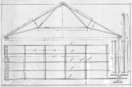
Original architectural drawing of the Roof Truss and Strong Backs for the McLeod Pulp Co. Ltd., Liverpool, NS.Drawing # 4, including cross section and dimensions. July 1910. 2019.1.12
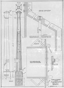
Architectural drawing of the Smoke Connections for the McLeod Pulp Co. Ltd., Liverpool, NS.Includes elevation, side views, plan of neck, measurements, diameters, and description of flue and smoke box requirements.July 1910. 2019.1.13