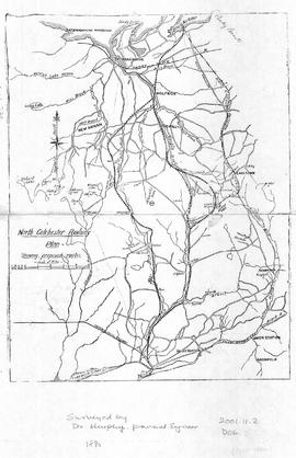
Map of North Colchester County, NS, showing proposed railway plan. Also includes existing Intercolonial Railway, Pictou Branch, Short Line through Tatamagouche, county towns, some waterways and roads. Surveyed by D. Murphy, Provincial Engineer, 1890. 2001.11.2
Original hand drawn map showing Main Street, Tatamagouche with lots and surnames including Hall, Ross, Mattatall, Mensie, McKenzie, Murphy, Fraser, Millar, Clark, and Town Hall. Minimal detail, although lots are numbered. Date and creator unknown. 1999.94.49
Original hand drawn map showing Amet Sound, Tatamagouche Bay, Brule Harbour, John Bay, divided by county lines in red ink (Cumberland, Colchester and Pictou Counties). Also includes Main Roads to Tatamagouche and River John. 1999.94.48
Copy of a map by Robert Byers , ca 1850 (copied by Gilbert Sutherland, Dec. 1882). Map shows town lots in Tatamagouche including lot owners, some businesses, wharves, streets, town public buildings and main roads (this is a partial map). 1999.94.47
Copy of a map by Robert Byers , ca 1850 (copied by A. M. Macnab, P.L. Surveyor, Nov. 1951). Map shows town lots in Tatamagouche, Main Road, New Annan Road, Back and Main Streets, Public Wharf and some lots identified with owner names. 1999.94.46
Original hand drawn map showing lots of property owners: Patterson, Patriquin, Wm. Bell, and others. Includes French River and Road to New Annan and Tatamagouche. 1999.94.42
Original hand drawn map showing Lot No. 27 of the DesBarres Grant and west side of Tatamagouche River. Specifically highlights portion of land conveyed to G. Tattrie (in red ink) with written description beside drawing. Enlarged area from Plan of DesBarres Grant. 1999.94.43
Original hand drawn map showing roads from Truro to Tatamagouche, both old and new. Also includes road to Farm Lake, Farm Lake, Whippy Lake, Black Lake, lots of surnames: Patterson, King, McKeen, Kennedy and others. 1999.94.41
Copy of a map by Robert Byers, Dy. Surveyor, 1850 (made by A. M. Macnab, P. D. Surveyor at unknown date)Shows Main Rd. through Tatamagouche and the French River Road. Includes lots of surnames Byers, Cutten, Morrison, MacBurnie, the School House, Campbell south line and other details. 1999.94.40
Copy of a map by John Gauld (made by A. M. Macnab, P. D. Surveyor). Unknown date.Shows plan of lots on the west side of Waugh's River, Main Rd. from Pictou to Amherst, New Annan Rd., Property Lots of Patterson, Campbell, Young, McDowal. McDonald, Brydon, Waugh. Also shows the edge of the Tatamagouche River. 1999.94.39