Original hand drawn map of "Follie Village, surveyed by me this 9th day of January 1850" by Donald Urquhart. Shows Colchester County land lots, owner names and directional measurements. Note: Map 2011.62.9 is very similar but has a few different names on the lots. Both maps were apparently done the same day by the same person. This map states, "This plan belongs to J. A. Fraser 2011.62.8
Original hand drawn map of A Plan of Lands in Folly Village, surveyed by Donald Urquhart, Dep. Sur., January 9, 1850.Shows Colchester County land lots, owner names and directional measurements. Note: Map 2011.62.8 is very similar but has a few different names on the lots. Both maps were apparently done the same day by the same person. 2011.62.9
Original hand drawn map of the Back Lots of the Township of Truro, NS. Copied by Isreal Longworth March 7, 1858. Includes land grants and names of property owners, some roads, marshlands and waterways. 2019.38.1
4 maps of Colchester County with colored markers to locate churches and dates of existence.Each map represents an approximate date: 1800, 1867, 1925 and 1977.Denominations include Presbyterian, Baptist, Methodist, Anglican, United, Congregationalists, Catholics and Other. 87.1.b
Original reproduction certificate issued to J. L. Peppard. Certifies that, "...he having expressed a desire to withdraw from the Lodge, is fully paid and has complied with the requirements, his leave is therefore granted." Signed at Truro, October 14, 1872. 2019.20.1
Original hand drawn map shows early downtown Truro, "Sept. 9, 1838" appears in pencil as well as "44".Shows the first streets in Truro with placement of homes and homeowner names. Includes Salmon River, Bible Hill (center), Young's Road, Mill Race, Boyd's Brook, Parade Square, Gaol, Court House, and Churches. Several items seem to have been corrected: erased and moved in the same hand - perhaps this was a work in progress. Creator unknown. 2007.107.1
Original reproduction certificate issued to J. L. Peppard. Certifies that he "...is raised to Degree of Master Mason in the Lodge Cobequid No. 37. Given at Masonic Hall, Halifax this 10th day of February in the year of our Lord 1872 and of Light 5872." English text is displayed on the left hand side of the certificate - Latin translation is on the right. 2019.20.2
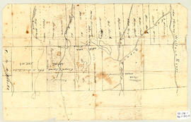
Topographic map of East Folly Mountain area showing Wallace River, East Branch River, Pines Brook, Totten Brook, divided lots with owner names including Fleming, McLain, Slack, Forsyth, Patten, Crowell, Barnhill, Archibald, Duncan, McNutt and Faulkner. Drawn November 1868 by unknown person. 92.246.1
Original hand drawn map which shows the topographical junction point of Colchester, Halifax and Guysborough Counties. This is an early, undated map, but since Guysborough was officially named in 1836, we know this map to be later than this date, but likely no later than 1875. The map shows land grants and grantee names, waterways and roads. Of note is Windsor College marked on 5 acres. 2019.24.1