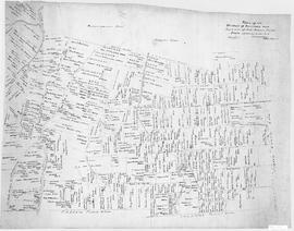
A map showing lots and property owners with boundaries of Onslow and Kemptown town lines, Pictou County line and includes Waugh’s River, French River, Tatamagouche East, Whippy Lake and Black Lake, south line of J.F.W. DesBarres Grant line. Roads include Old Road Onslow to Tatamagouche, West Branch Rd., Corktown Road, Truro Road, North River Road. 2002.146.1
Original hand drawn sketch plan showing the road by New Annan, the road by the Willow Church and the new line of road from Tatamagouche to Robert Cock's. Surveyed by Robert L. Byers, March 19, 1864. 1999.94.9
Original hand drawn map of a plan of the DesBarres Grant along the French River. Surnames include Patterson, Austin, Langille. Shows the road from Tatamagouche to New Annan, Colchester County, NS. No surveyor recorded, nor date. 1999.94.12
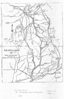
Map of North Colchester County, NS, showing proposed railway plan. Also includes existing Intercolonial Railway, Pictou Branch, Short Line through Tatamagouche, county towns, some waterways and roads. Surveyed by D. Murphy, Provincial Engineer, 1890. 2001.11.2
Original hand drawn map showing 20 acres described in words and plan for Alexander Matheson, Merchant in Colchester County, NS. Other surnames include Williamson, Pride, Carrie. Also shows Road to New Annan and Road to Truro. Surveyed by Robert L. Byers, Deputy Surveyor, New Annan, April 6, 1866. 1999.94.19
Original hand drawn map showing Campbell's Estate as well as a lot of A. Patterson. Includes Church Burying Grounds, Blair's Stage Stables, Tatamagouche Harbour, French River and roads to New Annan, Durham & Wallace. No surveyor nor exact date recorded. 1999.94.20
Original hand drawn map showing a "Copy Plan of a Road from new line of to Tatamagouche to William Bell's, New Annan. Surveyed Nov. 5, 1864 - likely by Robert L. Byers (cut off) 1999.94.24
Series forms part of the Colchester County school registers fonds and consists of 25 school registers for Wilson's School in Central New Annan, from 1940-1966 (missing: 1943-1944). Most registers measure 28x44cm or 26x38cm and contain 10-20 pages, though in some cases, only a few pages remain. Registers generally include a list of students' names, along with their sex, age, address, parent or guardians' names, as well as a record of attendance and general standing. Registers have been printed by the Nova Scotia Department of Education and data has been handwritten by the schoolteacher. 2023.1.2572 - 2023.1.2596
Original hand drawn map showing the main road through Tatamagouche, Colchester County, NS, including the water lots and land owners: Patterson, Campbell, Purves, McCurdy, Patriquin, Williamson,and Bryelon. Also shows Road to New Annan. No surveyor nor date given. 1999.94.17