Color reproduction map of the Town of Pictou, NS, 1878. Published by J. H. Meachan & Co, and C. R. Allen (surveyor). Was originally folded and likely accompanied an Atlas Book of Pictou County. Shows Town of Pictou including 1st, 2nd and 3rd Wards, streets, buildings, lots and owner names, Pictou Harbour and wharves plus many other details. 2007.25.7
Map of Onlsow Township, Colchester County, NS. Original grant issued Feb. 21, 1769. Traced by Gerald Byers, 1976. Shows names and lots of original grantees. 2002.141.15
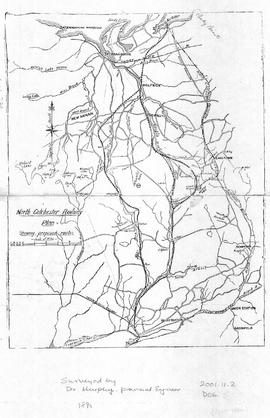
Map of North Colchester County, NS, showing proposed railway plan. Also includes existing Intercolonial Railway, Pictou Branch, Short Line through Tatamagouche, county towns, some waterways and roads. Surveyed by D. Murphy, Provincial Engineer, 1890. 2001.11.2
One black and white reproduction map created by D. D. Currie of Moncton in 1889. Shows hand illustrated streets, homes and large buildings throughout the Town of Truro and includes detailed labelled drawings of major businesses around the outer edge of the map. 94.137.1
An original reproduction color poster produced by J. F. Blanchard & Co. of Truro, NS in 1889. Features the styles of hats available for the spring and summer season. 91.62.2 and 2010.55.1
Reproduction map created by the Department of Marine and Fisheries in 1913, showing lighthouses, fog signals, wireless stations, life saving stations, buoys, list of radio-telegraph coast stations for communications with ships, marine species identified and a legend for minerals. 88.52
Reproduction map of Colchester County showing the locations of Major Shipyards, dates when first ships were built and names of shipbuilders. Inset of Tatamagouche included. Shows shipyards on the coastline of Colchester County and Shubenadacie River. Creator and date unknown. 88.59
A 1911 newsprint reproduction of an 1837 map of Truro NS. Shows homeowner names and buildings, businesses, main roads, Salmon River, Mill Race and Boyd's Brook. 88.92
4 maps of Colchester County with colored markers to locate churches and dates of existence.Each map represents an approximate date: 1800, 1867, 1925 and 1977.Denominations include Presbyterian, Baptist, Methodist, Anglican, United, Congregationalists, Catholics and Other. 87.1.b