Showing 91 results

Archival description
80 results with digital objects Show results with digital objects
Churches in Colchester
Item · [ca.1977]
4 maps of Colchester County with colored markers to locate churches and dates of existence.Each map represents an approximate date: 1800, 1867, 1925 and 1977.Denominations include Presbyterian, Baptist, Methodist, Anglican, United, Congregationalists, Catholics and Other. 87.1.b
Onslow Township, 1769
Item · 1976
Map of Onlsow Township, Colchester County, NS. Original grant issued Feb. 21, 1769. Traced by Gerald Byers, 1976. Shows names and lots of original grantees. 2002.141.15
Item · 1956
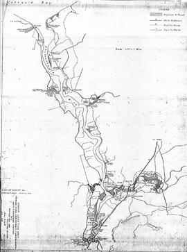
Copy of map drawn by H. Linneborn, Feb. 20, 1956. Map shows marsh locations along the Cobequid Bay & Minas Basin including roads, highways, trails, waterways, towns, railways and a legend. 2013.60.6A
Item · 1956
Copy of map drawn by H. Linneborn, Feb. 28, 1956. Map shows marsh locations along the Shubenacadie and Stewiacke Rivers in both Hants and Colchester County, NS. Includes roads, highways, trails, waterways, towns, railways and a legend. 2013.60.6B
Item · 1951
Part of Frank Patterson Collection
Copy of a map by Robert Byers , ca 1850 (copied by A. M. Macnab, P.L. Surveyor, Nov. 1951). Map shows town lots in Tatamagouche, Main Road, New Annan Road, Back and Main Streets, Public Wharf and some lots identified with owner names. 1999.94.46
Item · [ca. 1940 - 1950]
Plan of field drains for property owned by Kenneth Crowe (B. 1893), in Central Onslow, Colchester County, NS. Prepared by the Nova Scotia Agricultural College and shows fences, drain location and dimensions, grades, tile and the main road. 2016.73.2
Item · 1950
Blueprint copy of map showing CNR Truro Yard, including rail lines, streets, buildings, Round House, some property owner names. Area covers east to Gasper Lane, west to King Street as well as some of downtown, Esplanande St., Victoria St., East Prince St., Salmon River, plus insert showing continuation of Mulgrave Subdivision. Produced by CNR Government Railways, Atlantic Division, Engineers Office, Halifax, June 6, 1950. 2017.48.1
Item · 1946-47
Original printed reproduction of Truro Map, 1946-47, with Business Directory. Includes streets and many details of the town. Unknown printer. 2019.10.1
Camp Debert, 1940
Item · 1940
Printed reproduction map of Camp Debert, 1940, showing topography, roads, waterways, buildings, railways and many other details. 2002.141.31
Item · 1936
1936 original reproduction map of Truro showing streets and business ads around the edge of the map. Double sided with additional information. 2009.37.15b and 2012.6.3