Fonds consists of records of the activities of Robert Kim Stevens. Records were created and accumulated between about 1972 and 2003. Fonds is arranged into five series: correspondence, research material and publications, family files,maps, and drawings. Accession number 2003.010.
This history is a discrete item and was written by Clare Palmer in 1938 when she was about thirteen years old. It was likely part of a school assignment as there appears to be a comment written by the teacher on the last page. In his or her comment the teacher praises the value of the information provided by Clare and suggests that she donate it to the public archives. This handwritten, handmade history book is based on information provided by Mr. George Marks, Mrs. Bruce Marks, and Mr. and Mrs. E. A. Marks, whose contribution is acknowledged by Clare at the outset of her work. Her history includes chapters on the first settlers, the growth of the settlement, Ship Harbour industries, schools, transportation, churches, food, clothing, and lights; amusements, public buildings, prominent people, nature, and a final chapter that discusses Nichol Island and Wolfe Point as well as the origin of the name “Ship Harbour.” The book includes three hand drawn maps: one of Ship Harbour that features dwellings, G. L Monk’s store and mill, the J. L. factory, and the chapel; a second map depicting early roads in the area in 1863 as well as a ferry; and one small map of Nichol Island. The second last page also includes a photograph of the lighthouse at Wolfe Point on Nichol Island, which is were Clare lived with her family in the lightkeeper’s house. The book also includes two newspaper clippings, one about Daniel Weeks and one about the 50th anniversary of Mr. and Mrs. Edward Addington Marks which includes a picture. Accession number: 2013.013
Collection consists of forty monochrome aerial photographs of the Eastern Shore taken between 1931 and 1945. Also includes seven corresponding flight maps. Photographs illustrate the landscapes and coastlines of various locations along the Eastern Shore as they were in 1931-1945.
Areas covered by the aerial photographs within this collection include Owl's Head, Little Harbour, Clam Harbour, Burnt Point, Clam Bay, Lake Charlotte, Ship Harbour, Upper Lakeville, Oyster Pond, and the Jeddores. Accession number 2013.039
Fonds consists of records related to the activities of E. J. Webber during his time spent serving with the 2nd Reserve Battalion Halifax Rifles in World War II and his shared activities with his wife Babe Webber in her role as postmistress in Lake Charlotte during the 1950s. Records were created between 1941 and 1945, and between 1951 and 1955.
Fonds has been arranged into the following two series:
S1- 2nd Reserve Battalion Halifax Rifles
S2- Lake Charlotte Post Mistress Accession number 2009.045
Fonds consists of records related or possibly related to Robert A. Logan’s activities as a gold prospector in the area around Lake Charlotte, Halifax County, Nova Scotia. During the 1930s, Logan was Vice-President and manager of Prospectors Associated Activities Limited (sometimes abbreviated to PRASAC), a prospecting and mining company based in Lake Charlotte (then known as Ship Harbour Lake). Although he ceased his involvement with PRASAC in the 1940s, Logan may have continued prospecting in the area.
The records are primarily related to the purchase of mining and ore-processing equipment and include correspondence, brochures, catalogues, instructions, invoices, receipts, and notes. Accompanying one letter from a manufacturer is a photo of an offered piece of equipment (a concentrating table). Also included are a handwritten table of supplies needed to feed eight men on a 10-week expedition, a typed summary of gold mining operations for the years 1935-1936 and the first quarter of 1937, drafts and instructions for a letterhead design for PRASAC, and a copy of a hand-drawn map sketching shipping routes between PRASAC’s headquarters and major cities in Atlantic Canada, Eastern Canada, and the Northeastern United States. Although most mining-related records are from the 1930s, some date to the 1940s, and one product brochure dates to 1919.
Fonds also includes records related to Logan’s life and other activities in the Lake Charlotte area, including correspondence, instructions and brochures related to equipment which Logan bought for his home or personal use. Some instructions are prepared by Logan himself, including a set of handwritten notes and diagrams which details his repairs and installation of a well pump, as well as giving instructions for its use. In addition, fonds includes copies of a plan showing the lands of Lawrence Webber, Upper Lakeville, to be leased by the estate of J. Edward Webber, Lake Charlotte, dated August 8, 1967.
Fonds also includes a photograph of Robert A. Logan and his wife Daisy (Barrett) Logan taken in May of 1962. Accession number 2010.006.
Fonds consists of records of the family of F. Mitchell and the related Hosking family of Nova Scotia and includes financial records, records related to the Murray Harbour Black and Silver Fox Ranching Company, photographs, diary excerpts, correspondence, certificates, records related to tourism, wartime and military memorabilia, religious records, records related to the Freemasons, and music. Accession numbers 2003.011, 2006.001, 2010.011, 2010.012 and 2010.013.
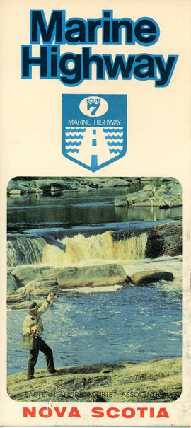
This item is a brochure produced by the Eastern Shore Tourist Association, featuring information on the Route 7 Marine Highway, a scenic route that forms part of the Trunk 7 highway and stretches from Dartmouth to Canso, skirting the Atlantic coastline through seaside villages and farming communities, past beaches, museums and other points of interest. The item consists of a map and a brief description of the Eastern Shore including local and natural attractions, communities, and history. The brochure also includes several images of scenery and attractions that can be found along the way. Accession number: 2013.018
The first three series of the fonds consist of essays and research written and compiled by Mr. Patrick Milligan and Mr. D. Engram’s grade ten students at Eastern Shore District High School between 1973 and 1980 as part of a class project on local history. The essays include information about various aspects of the history of the Eastern Shore such as industries and occupations, activities, cemeteries, churches, individuals, houses, education, and family and community history. Selected essays from Mr. Milligan’s local history course, 1974-1975, were compiled into a school publication called The Shore Thing, a preliminary copy of which is included in the fonds. The purpose of the book was to introduce students to their own area and familiarize them with the history of local communities along the Eastern Shore. It was placed in the school library for the benefit of all students. The fonds also consists of yearbooks and a newspaper published by the school during the first ten years of its operation. Accession numbers 2006.003, 2012.001
Fonds consists of records of the Eastern Shore Seaside Park System Citizen's Representative Committee and its members. Records include correspondence, meeting minutes, and park information. Accession numbers 2009.034, 2009.035, and 2013.019.
Fonds consists of records of the Association for Preservation of the Eastern Shore and its members. Records were created between 1969 and 1995, but predominantly between 1972 and 1983.
Records in the fonds are arranged into the following series:
S1- Ship Harbour National Park proposal
S2- Community activism
S3- Research material
S4- Correspondence
S5- Meeting minutes
S6- Memorandums of association
S7- Financial records
S8- Photographs
S9- Newspaper clippings Accession numbers 2009.035, 2009.036, 2013.019