Original hand drawn map shows property of Alexander Mattatal near the North Line of Onslow Township, next to the property of A. Patterson and D. Redmond and along the road from New Annan to Truro, Colchester County, NS.Signed A. I. White, Attorney General, Nov. 26, 1883. 2001.11.1
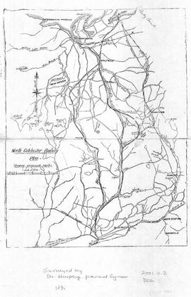
Map of North Colchester County, NS, showing proposed railway plan. Also includes existing Intercolonial Railway, Pictou Branch, Short Line through Tatamagouche, county towns, some waterways and roads. Surveyed by D. Murphy, Provincial Engineer, 1890. 2001.11.2
Map of Onlsow Township, Colchester County, NS. Original grant issued Feb. 21, 1769. Traced by Gerald Byers, 1976. Shows names and lots of original grantees. 2002.141.15
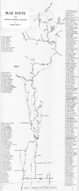
Hand drawn map showing the Mail Route from Marshall's Corner to Earltown, Colchester County in 1922-23.Includes roads and numbered dots along route which correspond to a list of home owners shown on the side of the map. Unknown creator and unknown exact date of creation. 2002.141.25
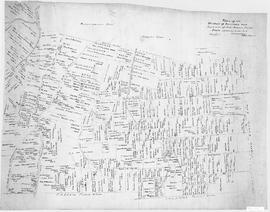
A map showing lots and property owners with boundaries of Onslow and Kemptown town lines, Pictou County line and includes Waugh’s River, French River, Tatamagouche East, Whippy Lake and Black Lake, south line of J.F.W. DesBarres Grant line. Roads include Old Road Onslow to Tatamagouche, West Branch Rd., Corktown Road, Truro Road, North River Road. 2002.146.1
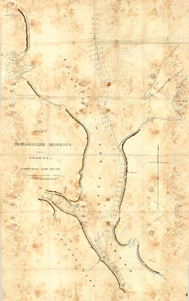
Original hand drawn map showing Tatmagouche (sic) Harbour, muddy flats dry at low tide, soundings at low water, Mingo's Wharf, Patterson's Wharf, Campbell's Saw Mill and Wharf, Bridge over the French River, New Government Wharf, Sand Point, Block House Point, Ingles Marsh. Ordinary rise of spring tides 6 feet 1 inch. No name of creator nor date. 2003.7.2
An original hand drawn map of the New Marsh, Lower Village (aka: Lower Truro, Colchester County, NS), showing numbered lots of land with owner names and acreage. Shows New Dyke Road, Soley's Creek, Cobequid Bay, Savage's Island and existing marsh area. Whole area = 51 ac, 2 qrs, 38 rods. Surveyed by Edmund Archibald, Land Surveyor, August 14, 1901. 2005.41.1
Original hand drawn map shows early downtown Truro, "Sept. 9, 1838" appears in pencil as well as "44".Shows the first streets in Truro with placement of homes and homeowner names. Includes Salmon River, Bible Hill (center), Young's Road, Mill Race, Boyd's Brook, Parade Square, Gaol, Court House, and Churches. Several items seem to have been corrected: erased and moved in the same hand - perhaps this was a work in progress. Creator unknown. 2007.107.1
Original hand drawn map of lands belonging to the Estate of the Late Dr. William McCulloch, D.D., of Bible Hill, 1895. Includes Old Pictou Road, fence boundaries, neighboring properties, lands of Experimental Farm, buildings, and the north bank of the Salmon River. There is a red perimeter line drawn around the McCulloch estate. Drawn by W. H. Trumaine (?) E. E., Sept. 19, 1895. 2007.107.2