Original hand drawn map which shows the property boundaries of land to be divided between 4 sons - James, William, Wilson and John Staples - heirs of William Staples Sr. of Onslow, NS., 1871.Edward Higgins, Thomas Chisholm and Alexander Barnhill state and witness that they were asked to divide the land between the 4 sons (presumably to settle an estate). 2011.81.1
Copy of map drawn by H. Linneborn, Feb. 20, 1956. Map shows marsh locations along the Cobequid Bay & Minas Basin including roads, highways, trails, waterways, towns, railways and a legend. 2013.60.6A
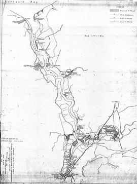
Copy of map drawn by H. Linneborn, Feb. 28, 1956. Map shows marsh locations along the Shubenacadie and Stewiacke Rivers in both Hants and Colchester County, NS. Includes roads, highways, trails, waterways, towns, railways and a legend. 2013.60.6B
The collection consists of files on various photographers that operated in Colchester County, containing newspaper clippings, photographs, and biographies. Items were compiled internally for an exhibition. 2015.22.1 - 9; 2021.40.1 - 19
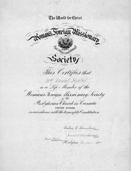
An original certificate which "certifies that Mrs. Daniel Hyslop (Hannah) is a Life Member of the Foreign Missionary Society of the Presbyterian Church of Canada, Eastern Division, in accordance with the terms of its Constitution. Halifax, June 1910. Signed by President and Treas. Sec.The Hislops (note spelling) lived in Onslow, NS. 2015.32.1
A collection of 5 maps which include: Approaches to St. John's Harbour (1921), The North Atlantic (1919), East Coast of North America (1880), Bay of Fundy, Southern Part (1934), and St. Martins, New Brunswick and NS (1934).These maps all belonged to Captain Jonathan Borden Marsh, who was from Economy, Colchester County. 2016.14.1 to 2016.14.5
Plan of field drains for property owned by Kenneth Crowe (B. 1893), in Central Onslow, Colchester County, NS. Prepared by the Nova Scotia Agricultural College and shows fences, drain location and dimensions, grades, tile and the main road. 2016.73.2
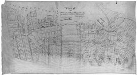
An original plan of building lots in Acadian (Acadia) Mines, Colchester County, NS, on lands belonging to the late Robert Forman Esq.Shows roads, lots, some adjacent property owners. Family tree of direct descendants is available on CHS Map Data Worksheet.Hand drawn "copy" by S.G.A. Morrison, May 17, 1888, Lornedale, NS 2016.96.1
A plan of the settlement of River John and vicinity shows the area from Seafoam to Tatamagouche, including land grants and owner names as well as many details and waterways. 2017.32.1