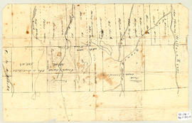
Topographic map of East Folly Mountain area showing Wallace River, East Branch River, Pines Brook, Totten Brook, divided lots with owner names including Fleming, McLain, Slack, Forsyth, Patten, Crowell, Barnhill, Archibald, Duncan, McNutt and Faulkner. Drawn November 1868 by unknown person. 92.246.1
An original hand drawn map of the New Marsh, Lower Village (aka: Lower Truro, Colchester County, NS), showing numbered lots of land with owner names and acreage. Shows New Dyke Road, Soley's Creek, Cobequid Bay, Savage's Island and existing marsh area. Whole area = 51 ac, 2 qrs, 38 rods. Surveyed by Edmund Archibald, Land Surveyor, August 14, 1901. 2005.41.1
Original hand drawn map of A Plan of Lands in Folly Village, surveyed by Donald Urquhart, Dep. Sur., January 9, 1850.Shows Colchester County land lots, owner names and directional measurements. Note: Map 2011.62.8 is very similar but has a few different names on the lots. Both maps were apparently done the same day by the same person. 2011.62.9
Original hand drawn map which shows the property boundaries of land to be divided between 4 sons - James, William, Wilson and John Staples - heirs of William Staples Sr. of Onslow, NS., 1871.Edward Higgins, Thomas Chisholm and Alexander Barnhill state and witness that they were asked to divide the land between the 4 sons (presumably to settle an estate). 2011.81.1
1 original hand drawn map showing new proposed road as continuation of Gunn's Road, connecting from West Branch Road to River John Road and the properties it will cross (McKay, Munroe, McBain and Langille's). Surveyed by Gilbert Sutherland Feb. 11, 1884.Confirmed - May Session, 1884. Recorded in Road Bank pgs 476-9. 2019.45.1
Original hand drawn map of land grants and grantee names in part of Londonderry Township, Colchester County, NS. Includes surnames McLellan, Spencer, Denney, Dill, McLean, Skinner, and Reagh. Shows waterways and roads (unlabelled). 92.358.13
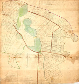
Original map showing Masstown Marsh including roads, waterways and granted lots with grantee names and acreages.Coloured: green indicates upland and islands, yellow indicates drains, creeks and ponds, brown indicates roads, red indicates dykes.Made by Thos. Miller, Surveyor, on July 25, 1863. Copy made for made for James Campbell by A. W. McLelan on September 12, 1863. 92.358.28
Original hand drawn map shows early downtown Truro, "Sept. 9, 1838" appears in pencil as well as "44".Shows the first streets in Truro with placement of homes and homeowner names. Includes Salmon River, Bible Hill (center), Young's Road, Mill Race, Boyd's Brook, Parade Square, Gaol, Court House, and Churches. Several items seem to have been corrected: erased and moved in the same hand - perhaps this was a work in progress. Creator unknown. 2007.107.1
Original hand drawn map of lands belonging to the Estate of the Late Dr. William McCulloch, D.D., of Bible Hill, 1895. Includes Old Pictou Road, fence boundaries, neighboring properties, lands of Experimental Farm, buildings, and the north bank of the Salmon River. There is a red perimeter line drawn around the McCulloch estate. Drawn by W. H. Trumaine (?) E. E., Sept. 19, 1895. 2007.107.2