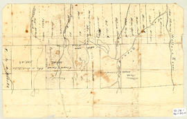
Topographic map of East Folly Mountain area showing Wallace River, East Branch River, Pines Brook, Totten Brook, divided lots with owner names including Fleming, McLain, Slack, Forsyth, Patten, Crowell, Barnhill, Archibald, Duncan, McNutt and Faulkner. Drawn November 1868 by unknown person. 92.246.1
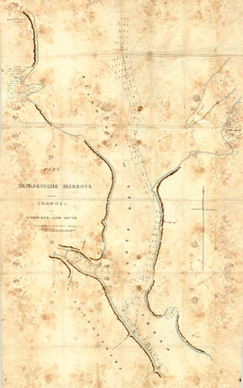
Original hand drawn map showing Tatmagouche (sic) Harbour, muddy flats dry at low tide, soundings at low water, Mingo's Wharf, Patterson's Wharf, Campbell's Saw Mill and Wharf, Bridge over the French River, New Government Wharf, Sand Point, Block House Point, Ingles Marsh. Ordinary rise of spring tides 6 feet 1 inch. No name of creator nor date. 2003.7.2
Original hand drawn map which shows the property boundaries of land to be divided between 4 sons - James, William, Wilson and John Staples - heirs of William Staples Sr. of Onslow, NS., 1871.Edward Higgins, Thomas Chisholm and Alexander Barnhill state and witness that they were asked to divide the land between the 4 sons (presumably to settle an estate). 2011.81.1
A collection of 5 maps which include: Approaches to St. John's Harbour (1921), The North Atlantic (1919), East Coast of North America (1880), Bay of Fundy, Southern Part (1934), and St. Martins, New Brunswick and NS (1934).These maps all belonged to Captain Jonathan Borden Marsh, who was from Economy, Colchester County. 2016.14.1 to 2016.14.5
Original hand drawn map shows property of Alexander Mattatal near the North Line of Onslow Township, next to the property of A. Patterson and D. Redmond and along the road from New Annan to Truro, Colchester County, NS.Signed A. I. White, Attorney General, Nov. 26, 1883. 2001.11.1
1 original hand drawn map showing new proposed road as continuation of Gunn's Road, connecting from West Branch Road to River John Road and the properties it will cross (McKay, Munroe, McBain and Langille's). Surveyed by Gilbert Sutherland Feb. 11, 1884.Confirmed - May Session, 1884. Recorded in Road Bank pgs 476-9. 2019.45.1
Fonds consists of personal, business, association and institutional records relating to the Municipality of the District of St. Mary’s, with a special emphasis on Sherbrooke, Nova Scotia.
Included are meeting minutes, reports, and news from local associations including Heritage Goldenville Society, Royal Canadian Legion, Queen’s Lodge No. 34 A. F. & A. M., Sherbrooke Amateur Athletic Association, Sherbrooke Hockey League, St. Mary’s Boat Club, St. Mary’s Curling Club, St. Mary’s Driving Society, St. Mary’s Guest Home Society, St. Mary’s Historical Society, St. Mary’s District Rink Association and RecPlex, St. Mary’s River Association (1924-2003, predominantly 1970s-early 2000s); correspondence from the Department of Fisheries (c. 1920s); news clippings, reports, and press releases for local events including Communities in Bloom and Old Fashioned Christmas at Sherbrooke Village (1945-2002, predominantly early 2000s); maps, budgets, reports, meeting minutes, and other paperwork from Historic Sherbrooke Village (1971-1977); ledgers, news clippings, pulp samples from a local mill, and other papers related to local merchants and industry in the region (1872-2001, predominantly 1948-1968); papers from the Presbyterian, United, and St. James Anglican Churches, as well as the St. Mary’s Municipal School Board, Post Office, Library, St. Mary’s District Lions Club, St. Mary’s Memorial Hospital, Sunset Rest Cemetery, Down East Fire Fighters Association and Fire Department (1915-1996, predominantly 1930s-2000s); newspapers with Sherbrooke-related content, including the Family Herald and Weekly Star (1948), The Eastern Chronicle (1919), and Canso Breeze (1965-1966); a diary, family photographs, horse racing album, military service records, business ledgers, and personal family papers of Frank Jordan himself alongside unpublished memoirs and other papers from other Sherbrooke residents on the subject of local history; photographs, personal accounts, and newsletters about the St. Mary’s River (1900-2002, primarily concerning the 1956 flood). Also included in the collection are oral histories recorded at meetings of the St. Mary’s Historical Society (1978-1990).
Fonds consists of the following series:Series 1: Andersons and Murdochs, Collected PapersSeries 2: Associations, LocalSeries 3: Department of FisheriesSeries 4: Diary (Digitized)Series 5: Emergency Measures OrganizationSeries 6: Events, LocalSeries 7: Historic Sherbrooke VillageSeries 8: Horse Racing Album (Digitized)Series 9: Business, LocalSeries 10: Institutions, LocalSeries 11: Municipality of the District of St. Mary’sSeries 12: Newspapers, RegionalSeries 13: Oral HistoriesSeries 14: Papers, CollectedSeries 15: Photographs (Digitized)Series 16: Periodicals, Collected RegionalSeries 17: St. Mary’s District Development AssociationSeries 18: St. Mary’s Historical Society and Historical MaterialSeries 19: St. Mary’s River 2020.011
Consists of a hydrographic map of the North Atlantic Ocean. Recorded observations (Notices to Mariners) of October 1888 indicated in red print include hurricane paths and dates, ship wreaks, fog belts, icebergs, general drift of ocean currents and prevailing winds (blue print) among other details. Forecasts for November 1888.This map belonged to Capt. John Congdon of Great Village, NS. He was the Master of the ship "Bedford". 90.77.3
An original plan of building lots in Acadian (Acadia) Mines, Colchester County, NS, on lands belonging to the late Robert Forman Esq.Shows roads, lots, some adjacent property owners. Family tree of direct descendants is available on CHS Map Data Worksheet.Hand drawn "copy" by S.G.A. Morrison, May 17, 1888, Lornedale, NS 2016.96.1
Original hand drawn map of lands belonging to the Estate of the Late Dr. William McCulloch, D.D., of Bible Hill, 1895. Includes Old Pictou Road, fence boundaries, neighboring properties, lands of Experimental Farm, buildings, and the north bank of the Salmon River. There is a red perimeter line drawn around the McCulloch estate. Drawn by W. H. Trumaine (?) E. E., Sept. 19, 1895. 2007.107.2