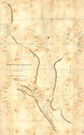
Original hand drawn map showing Tatmagouche (sic) Harbour, muddy flats dry at low tide, soundings at low water, Mingo's Wharf, Patterson's Wharf, Campbell's Saw Mill and Wharf, Bridge over the French River, New Government Wharf, Sand Point, Block House Point, Ingles Marsh. Ordinary rise of spring tides 6 feet 1 inch. No name of creator nor date. 2003.7.2
Architectural drawings for residence at 38 Dominion Street, Truro, NS.Built in 1903, this 2.5 story wood frame structure was designed by E. D. Vernon. It is an excellent example of the Queen Anne Style with many classical details including bays, gables, fluted Corinthian columns, Palladian windows, and dentils. It was built by Frank Stanfield Sr. for his bride beside the original family property #44. 87.2.2 to 87.2.9
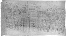
Original hand drawn map of downtown Truro, 1900, labelled with red dots to indicate present location of arc street lights - 48 in all. Red circles indicate I.C.R. (Intercolonial Railway) lights. Shows Salmon River and part of the railway through Truro. 2019.7.1
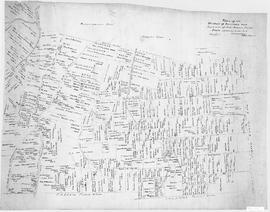
Map of downtown Truro showing intersection of Prince and Outram Streets with proposed subdivision of Dr. John Waddell property lying between Prince Street and the Pictou Railway line. Includes lots with measurements and some businesses. Surveyed by Isaac N. Archibald, P. D. Surveyor, County of Colchester, March 29, 1866. 2019.9.1
A plan of the settlement of River John and vicinity shows the area from Seafoam to Tatamagouche, including land grants and owner names as well as many details and waterways. 2017.32.1
A map showing lots and property owners with boundaries of Onslow and Kemptown town lines, Pictou County line and includes Waugh’s River, French River, Tatamagouche East, Whippy Lake and Black Lake, south line of J.F.W. DesBarres Grant line. Roads include Old Road Onslow to Tatamagouche, West Branch Rd., Corktown Road, Truro Road, North River Road. 2002.146.1
1 original hand drawn map showing new proposed road as continuation of Gunn's Road, connecting from West Branch Road to River John Road and the properties it will cross (McKay, Munroe, McBain and Langille's). Surveyed by Gilbert Sutherland Feb. 11, 1884.Confirmed - May Session, 1884. Recorded in Road Bank pgs 476-9. 2019.45.1
An original hand drawn map of the New Marsh, Lower Village (aka: Lower Truro, Colchester County, NS), showing numbered lots of land with owner names and acreage. Shows New Dyke Road, Soley's Creek, Cobequid Bay, Savage's Island and existing marsh area. Whole area = 51 ac, 2 qrs, 38 rods. Surveyed by Edmund Archibald, Land Surveyor, August 14, 1901. 2005.41.1
Original hand drawn map which shows the property boundaries of land to be divided between 4 sons - James, William, Wilson and John Staples - heirs of William Staples Sr. of Onslow, NS., 1871.Edward Higgins, Thomas Chisholm and Alexander Barnhill state and witness that they were asked to divide the land between the 4 sons (presumably to settle an estate). 2011.81.1