This history is a discrete item and was written by Clare Palmer in 1938 when she was about thirteen years old. It was likely part of a school assignment as there appears to be a comment written by the teacher on the last page. In his or her comment the teacher praises the value of the information provided by Clare and suggests that she donate it to the public archives. This handwritten, handmade history book is based on information provided by Mr. George Marks, Mrs. Bruce Marks, and Mr. and Mrs. E. A. Marks, whose contribution is acknowledged by Clare at the outset of her work. Her history includes chapters on the first settlers, the growth of the settlement, Ship Harbour industries, schools, transportation, churches, food, clothing, and lights; amusements, public buildings, prominent people, nature, and a final chapter that discusses Nichol Island and Wolfe Point as well as the origin of the name “Ship Harbour.” The book includes three hand drawn maps: one of Ship Harbour that features dwellings, G. L Monk’s store and mill, the J. L. factory, and the chapel; a second map depicting early roads in the area in 1863 as well as a ferry; and one small map of Nichol Island. The second last page also includes a photograph of the lighthouse at Wolfe Point on Nichol Island, which is were Clare lived with her family in the lightkeeper’s house. The book also includes two newspaper clippings, one about Daniel Weeks and one about the 50th anniversary of Mr. and Mrs. Edward Addington Marks which includes a picture. Accession number: 2013.013
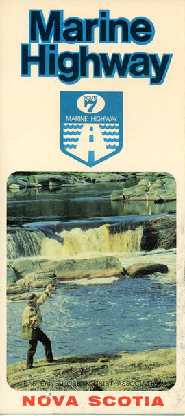
This item is a brochure produced by the Eastern Shore Tourist Association, featuring information on the Route 7 Marine Highway, a scenic route that forms part of the Trunk 7 highway and stretches from Dartmouth to Canso, skirting the Atlantic coastline through seaside villages and farming communities, past beaches, museums and other points of interest. The item consists of a map and a brief description of the Eastern Shore including local and natural attractions, communities, and history. The brochure also includes several images of scenery and attractions that can be found along the way. Accession number: 2013.018
1 original hand drawn map showing new proposed road as continuation of Gunn's Road, connecting from West Branch Road to River John Road and the properties it will cross (McKay, Munroe, McBain and Langille's). Surveyed by Gilbert Sutherland Feb. 11, 1884.Confirmed - May Session, 1884. Recorded in Road Bank pgs 476-9. 2019.45.1
Original hand drawn map of "Follie Village, surveyed by me this 9th day of January 1850" by Donald Urquhart. Shows Colchester County land lots, owner names and directional measurements. Note: Map 2011.62.9 is very similar but has a few different names on the lots. Both maps were apparently done the same day by the same person. This map states, "This plan belongs to J. A. Fraser 2011.62.8
Original hand drawn map of A Plan of Lands in Folly Village, surveyed by Donald Urquhart, Dep. Sur., January 9, 1850.Shows Colchester County land lots, owner names and directional measurements. Note: Map 2011.62.8 is very similar but has a few different names on the lots. Both maps were apparently done the same day by the same person. 2011.62.9
Topographic map of East Folly Mountain area showing Wallace River, East Branch River, Pines Brook, Totten Brook, divided lots with owner names including Fleming, McLain, Slack, Forsyth, Patten, Crowell, Barnhill, Archibald, Duncan, McNutt and Faulkner. Drawn November 1868 by unknown person. 92.246.1
Original hand drawn map of Mill Brook, Colchester County. Granted lots near border of western side of DesBarres Grant including family names: Halliday, George, Swan, Clark, Pugh, Oliver. Stamped with a seal visible on paper - appears to belong with a land grant for James Clark.Surveyed by John Spry Morris, Surveyor General, Halifax, Oct. 11, 1845. 88.14
Original hand drawn map of land grants and grantee names in part of Londonderry Township, Colchester County, NS. Includes surnames McLellan, Spencer, Denney, Dill, McLean, Skinner, and Reagh. Shows waterways and roads (unlabelled). 92.358.13
An original hand drawn map which states, "I certify that this plan is a true and correct copy of a Plan of the Partitions of the Township of Londonderry filed in this office. Dept. of Crown Lands, 12 Feby 1861, Samuel P. Fairbanks, Comm. Crown Lands.Includes granted lands, names of lot owners and acreage. 2011.62.10
Street map of 1878 Truro and Bible Hill including names on many properties and a separate list of names and businesses identified. Shows railway, buildings and Salmon River. Very detailed and could be a mate to the A. F. Church Co. map series, but this is not confirmed. Appears very similar. 88.20