One black and white reproduction map created by D. D. Currie of Moncton in 1889. Shows hand illustrated streets, homes and large buildings throughout the Town of Truro and includes detailed labelled drawings of major businesses around the outer edge of the map. 94.137.1
Map shows Truro Township along the Salmon River, including the first main roads of the Town. Includes grantee lots and owner names with inset of Birch Island in Upper Village. 93.40.1a
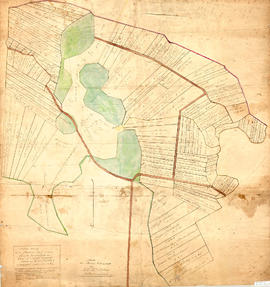
Original map showing Masstown Marsh including roads, waterways and granted lots with grantee names and acreages.Coloured: green indicates upland and islands, yellow indicates drains, creeks and ponds, brown indicates roads, red indicates dykes.Made by Thos. Miller, Surveyor, on July 25, 1863. Copy made for made for James Campbell by A. W. McLelan on September 12, 1863. 92.358.28
Original hand drawn map of land grants and grantee names in part of Londonderry Township, Colchester County, NS. Includes surnames McLellan, Spencer, Denney, Dill, McLean, Skinner, and Reagh. Shows waterways and roads (unlabelled). 92.358.13
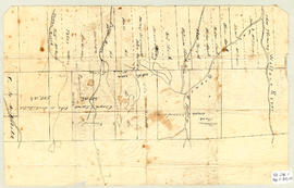
Topographic map of East Folly Mountain area showing Wallace River, East Branch River, Pines Brook, Totten Brook, divided lots with owner names including Fleming, McLain, Slack, Forsyth, Patten, Crowell, Barnhill, Archibald, Duncan, McNutt and Faulkner. Drawn November 1868 by unknown person. 92.246.1
Consists of a hydrographic map of the North Atlantic Ocean. Recorded observations (Notices to Mariners) of October 1888 indicated in red print include hurricane paths and dates, ship wreaks, fog belts, icebergs, general drift of ocean currents and prevailing winds (blue print) among other details. Forecasts for November 1888.This map belonged to Capt. John Congdon of Great Village, NS. He was the Master of the ship "Bedford". 90.77.3
A 1911 newsprint reproduction of an 1837 map of Truro NS. Shows homeowner names and buildings, businesses, main roads, Salmon River, Mill Race and Boyd's Brook. 88.92
Street map of 1878 Truro and Bible Hill including names on many properties and a separate list of names and businesses identified. Shows railway, buildings and Salmon River. Very detailed and could be a mate to the A. F. Church Co. map series, but this is not confirmed. Appears very similar. 88.20
Original hand drawn map of Mill Brook, Colchester County. Granted lots near border of western side of DesBarres Grant including family names: Halliday, George, Swan, Clark, Pugh, Oliver. Stamped with a seal visible on paper - appears to belong with a land grant for James Clark.Surveyed by John Spry Morris, Surveyor General, Halifax, Oct. 11, 1845. 88.14
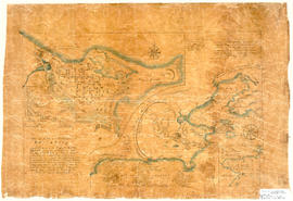
Hand drawn map showing the City and Harbour of Louisburg (after 1758), including buildings, raods, coastline, fortifications, troop details, inset of City and Gabarus Bay. Unknown creator and date. 87.12(i)