Original printed reproduction of Truro Map, 1946-47, with Business Directory. Includes streets and many details of the town. Unknown printer. 2019.10.1
Collection consists of original grants and deeds for properties located within the St. Mary's region. Some deeds include small, hand-drawn maps of the transacted property and surrounding properties, often showing property relationship to waterways including the three branches of the St. Mary's River. 2020.039; 2019.008; 2020.008
4 maps of Colchester County with colored markers to locate churches and dates of existence.Each map represents an approximate date: 1800, 1867, 1925 and 1977.Denominations include Presbyterian, Baptist, Methodist, Anglican, United, Congregationalists, Catholics and Other. 87.1.b
Map of Onlsow Township, Colchester County, NS. Original grant issued Feb. 21, 1769. Traced by Gerald Byers, 1976. Shows names and lots of original grantees. 2002.141.15
Fonds consists of records of the Eastern Shore Seaside Park System Citizen's Representative Committee and its members. Records include correspondence, meeting minutes, and park information. Accession numbers 2009.034, 2009.035, and 2013.019.
Fonds consists of records of the Association for Preservation of the Eastern Shore and its members. Records were created between 1969 and 1995, but predominantly between 1972 and 1983.
Records in the fonds are arranged into the following series:
S1- Ship Harbour National Park proposal
S2- Community activism
S3- Research material
S4- Correspondence
S5- Meeting minutes
S6- Memorandums of association
S7- Financial records
S8- Photographs
S9- Newspaper clippings Accession numbers 2009.035, 2009.036, 2013.019
The first three series of the fonds consist of essays and research written and compiled by Mr. Patrick Milligan and Mr. D. Engram’s grade ten students at Eastern Shore District High School between 1973 and 1980 as part of a class project on local history. The essays include information about various aspects of the history of the Eastern Shore such as industries and occupations, activities, cemeteries, churches, individuals, houses, education, and family and community history. Selected essays from Mr. Milligan’s local history course, 1974-1975, were compiled into a school publication called The Shore Thing, a preliminary copy of which is included in the fonds. The purpose of the book was to introduce students to their own area and familiarize them with the history of local communities along the Eastern Shore. It was placed in the school library for the benefit of all students. The fonds also consists of yearbooks and a newspaper published by the school during the first ten years of its operation. Accession numbers 2006.003, 2012.001
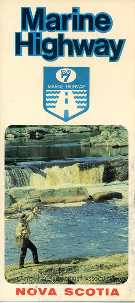
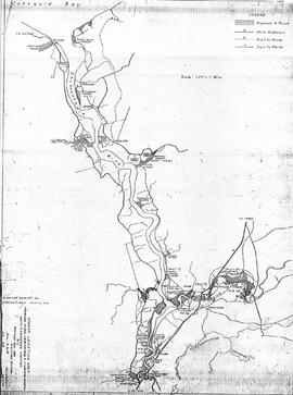
This item is a brochure produced by the Eastern Shore Tourist Association, featuring information on the Route 7 Marine Highway, a scenic route that forms part of the Trunk 7 highway and stretches from Dartmouth to Canso, skirting the Atlantic coastline through seaside villages and farming communities, past beaches, museums and other points of interest. The item consists of a map and a brief description of the Eastern Shore including local and natural attractions, communities, and history. The brochure also includes several images of scenery and attractions that can be found along the way. Accession number: 2013.018
Copy of map drawn by H. Linneborn, Feb. 20, 1956. Map shows marsh locations along the Cobequid Bay & Minas Basin including roads, highways, trails, waterways, towns, railways and a legend. 2013.60.6A
Copy of map drawn by H. Linneborn, Feb. 28, 1956. Map shows marsh locations along the Shubenacadie and Stewiacke Rivers in both Hants and Colchester County, NS. Includes roads, highways, trails, waterways, towns, railways and a legend. 2013.60.6B