Showing 162 results

Archival description
98 results with digital objects Show results with digital objects
Item · 1758
Item is a map of New England and Nova Scotia showing Newfoundland and Cape Breton Island situated in the Gulf of St. Lawrence. The map includes identified fishing banks. MAP 247
Item · after 1758
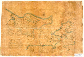
Hand drawn map showing the City and Harbour of Louisburg (after 1758), including buildings, raods, coastline, fortifications, troop details, inset of City and Gabarus Bay. Unknown creator and date. 87.12(i)
Canada
Item · 1761
Item is an 18th century map of Canada was produced late in Kitchin's career and engraved by John Gibson. Gibson and Kitchin worked together on a number of projects during their lives. MAP 688
J. F. W. DesBarres
Series · 1776
Part of Eastern Shore Archives map collection
Joseph Frederick Wallet Des Barres was born in 1729 in France. He died on October 27, 1824 in Halifax. He entered the Royal Military Academy at Woolwich (London), England in the early 1750s, where he studied fortifications, surveying, and drafting. In 1756, he went to North America where he began his military career as a lieutenant in the Royal American Regiment and saw action against the French at Louisbourg, Quebec, and Newfoundland, during which time he also began surveying in those regions. He was a military engineer, surveyor, and later Governor of Cape Breton and Prince Edward Island.By 1763, his surveying and mapping skills had been noted and he was commissioned by the Admiralty to chart the coast and offshore waters of Nova Scotia from 1764 to 1773. He later published his charts and views, together with contributions from Samuel Holland and others, in a navigational atlas that he produced on behalf of the Admiralty in 1777. The atlas was called The Atlantic Neptune, the final version of which was published in 1781.The Atlantic Neptune consisted of detailed charts and views of North American coasts, with the charts containing both topographical and hydrographical details.Series forms part of the map collection and consists of maps surveyed By Joseph Frederick Wallet Des Barres during the summers of 1764 to 1773 by order of the Right Honourable Lord Commissioners of the Admiralty. The maps show the diversities of the coast, ledges, shoals, rocks, soundings, and the quality of the bottom. Accession number: 2003.087
Londonderry Township, 1780
Item · 1780
Londonderry Township map showing Planter Grantees and Lots. Traced from original by James Fulton, D. Surveyor, abt. 1780. Downscaled tracing done by Bruce McNutt, 1983. 2019.19.1
Robert Kim Stevens fonds
Fonds · [ca. 1972]-[ca. 2002]
Fonds consists of records of the activities of Robert Kim Stevens. Records were created and accumulated between about 1972 and 2003. Fonds is arranged into five series: correspondence, research material and publications, family files,maps, and drawings. Accession number 2003.010.
Maps
Series · ca. 1740-1780
Part of Robert Kim Stevens fonds
Series forms part of Robert Kim Stevens fonds and consists of one early Italian map of Acadia, Ile Royale and the surrounding area including Ile St. Jean. The map was likely drawn by Jacques-Nicholas Bellin, a French-born hydrographer and geographer who produced many maps of Canada and other French territories in North America and was chief cartographer of the French Navy in 1721 and later Official Hydrographer of the King. 2013.026
Item · 1784
Original hand drawn map of land grants and grantee names in part of Londonderry Township, Colchester County, NS. Includes surnames McLellan, Spencer, Denney, Dill, McLean, Skinner, and Reagh. Shows waterways and roads (unlabelled). 92.358.13
Item · 1788
Map shows Truro Township along the Salmon River, including the first main roads of the Town. Includes grantee lots and owner names with inset of Birch Island in Upper Village. 93.40.1a