Original hand drawn map of "Follie Village, surveyed by me this 9th day of January 1850" by Donald Urquhart. Shows Colchester County land lots, owner names and directional measurements. Note: Map 2011.62.9 is very similar but has a few different names on the lots. Both maps were apparently done the same day by the same person. This map states, "This plan belongs to J. A. Fraser 2011.62.8
Original hand drawn map of A Plan of Lands in Folly Village, surveyed by Donald Urquhart, Dep. Sur., January 9, 1850.Shows Colchester County land lots, owner names and directional measurements. Note: Map 2011.62.8 is very similar but has a few different names on the lots. Both maps were apparently done the same day by the same person. 2011.62.9
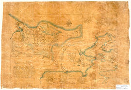
Hand drawn map showing the City and Harbour of Louisburg (after 1758), including buildings, raods, coastline, fortifications, troop details, inset of City and Gabarus Bay. Unknown creator and date. 87.12(i)
Original hand drawn map showing Amet Sound, Tatamagouche Bay, Brule Harbour, John Bay, divided by county lines in red ink (Cumberland, Colchester and Pictou Counties). Also includes Main Roads to Tatamagouche and River John. 1999.94.48
3 sheets of original technical drawings for an Army Stretcher.Sheet 1: top and side view, Sheet 2: detail of hinge, Sheet 3: detail of wood wheel and shoulder straps.Includes dimensions and technical specs. Drawn by George Mosher c 1900. 2019.1.1 to 2019.1.3
Original hand drawn map of the Back Lots of the Township of Truro, NS. Copied by Isreal Longworth March 7, 1858. Includes land grants and names of property owners, some roads, marshlands and waterways. 2019.38.1
Original hand drawn map showing Campbell's Estate as well as a lot of A. Patterson. Includes Church Burying Grounds, Blair's Stage Stables, Tatamagouche Harbour, French River and roads to New Annan, Durham & Wallace. No surveyor nor exact date recorded. 1999.94.20
Original hand written Charter of the Presbyterian Church in Truro, 1828.Outlines the Charter and names of congregation, with seals and witnesses. 2011.61.7
Original drawing of Victorian architectural details for Dr. D. H. Muir House on Prince St., Truro, NS, c1880.Shows Mantle in the Drawing Room and the Arch to Nook. 87.20(ii)
Map shows Truro Township along the Salmon River, including the first main roads of the Town. Includes grantee lots and owner names with inset of Birch Island in Upper Village. 93.40.1a