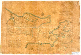
Hand drawn map showing the City and Harbour of Louisburg (after 1758), including buildings, raods, coastline, fortifications, troop details, inset of City and Gabarus Bay. Unknown creator and date. 87.12(i)
Original hand drawn map showing Amet Sound, Tatamagouche Bay, Brule Harbour, John Bay, divided by county lines in red ink (Cumberland, Colchester and Pictou Counties). Also includes Main Roads to Tatamagouche and River John. 1999.94.48
Original hand drawn map showing lots of property owners: Patterson, Patriquin, Wm. Bell, and others. Includes French River and Road to New Annan and Tatamagouche. 1999.94.42
Original hand drawn map showing Lot No. 27 of the DesBarres Grant and west side of Tatamagouche River. Specifically highlights portion of land conveyed to G. Tattrie (in red ink) with written description beside drawing. Enlarged area from Plan of DesBarres Grant. 1999.94.43
Original hand drawn map showing roads from Truro to Tatamagouche, both old and new. Also includes road to Farm Lake, Farm Lake, Whippy Lake, Black Lake, lots of surnames: Patterson, King, McKeen, Kennedy and others. 1999.94.41
Original hand drawn map showing Tatamagouche town lots on the property of William Campbell Esq.Includes Main Road through Tatamagouche, Road to French River, lot divisions and some surnames. 1999.94.38
Original hand drawn map showing West Side of Waugh's River. Very light pencil (graphite) and watercolour, no names visible. Shows New Road through Tatamagouche. 1999.94.36
Original hand drawn map showing East and West Branch of French River, including a plan of Robert and Henry Oliver's Grants in the settlement of New Annan with a section of DesBarres Grant. 1999.94.35
Original hand drawn map showing Road to Wallace, Tatamagouche Harbour, Bass Creek, Henderson Creek, Matatals Brook, French River and lots of DesBarres Grant and several others. Surnames include Campbell, Langill, Patriquin, Joyce and others. 1999.94.32