Showing 70 results

Archival description
63 results with digital objects Show results with digital objects
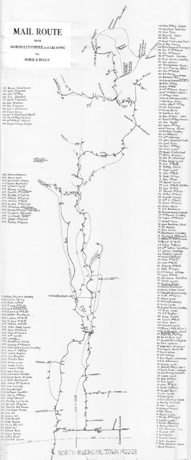
Frank Patterson Collection
Collection · 1999
A collection of 40 original hand-drawn maps of the Tatamagouche area, including areas of the DesBarres Grant. Maps show land grants, names of property owners, waterways, roads and other details. Dates range from 1835 to 1951 with the majority c1850. Surveyors include John Spry Morris, John Gauld, Robert Byers, Charles Morris, Alexander Miller, Gilbert Sutherland. Also included is one Public Notice for a Sherriff's Sale in 1855. 1999.94.1a to 1999.94.49
Item · 1922
Hand drawn map showing the Mail Route from Marshall's Corner to Earltown, Colchester County in 1922-23.Includes roads and numbered dots along route which correspond to a list of home owners shown on the side of the map. Unknown creator and unknown exact date of creation. 2002.141.25
Item · 1918
Part of Frank Patterson Collection
Original hand drawn map showing Lot No. 27 of the DesBarres Grant and west side of Tatamagouche River. Specifically highlights portion of land conveyed to G. Tattrie (in red ink) with written description beside drawing. Enlarged area from Plan of DesBarres Grant. 1999.94.43
Item · 1908
Part of George Mosher Collection
Original architectural drawing for a Boiler Setting for the Kent Lumber Co. including vertical cross sections and end elevation with measurements and building details. Kent Lumber Co. operated in Colchester County, NS. 2019.1.8
Item · 1908
A map showing lots and property owners with boundaries of Onslow and Kemptown town lines, Pictou County line and includes Waugh’s River, French River, Tatamagouche East, Whippy Lake and Black Lake, south line of J.F.W. DesBarres Grant line. Roads include Old Road Onslow to Tatamagouche, West Branch Rd., Corktown Road, Truro Road, North River Road. 2002.146.1
Collection · 1903
Architectural drawings for residence at 38 Dominion Street, Truro, NS.Built in 1903, this 2.5 story wood frame structure was designed by E. D. Vernon. It is an excellent example of the Queen Anne Style with many classical details including bays, gables, fluted Corinthian columns, Palladian windows, and dentils. It was built by Frank Stanfield Sr. for his bride beside the original family property #44. 87.2.2 to 87.2.9
Item · 1901
An original hand drawn map of the New Marsh, Lower Village (aka: Lower Truro, Colchester County, NS), showing numbered lots of land with owner names and acreage. Shows New Dyke Road, Soley's Creek, Cobequid Bay, Savage's Island and existing marsh area. Whole area = 51 ac, 2 qrs, 38 rods. Surveyed by Edmund Archibald, Land Surveyor, August 14, 1901. 2005.41.1
Truro Street Map, 1900
Item · [1900]
Original hand drawn map of downtown Truro, 1900.Shows Salmon River and named streets only. 2019.7.2
Army Stretcher
Item · [1900]
Part of George Mosher Collection
3 sheets of original technical drawings for an Army Stretcher.Sheet 1: top and side view, Sheet 2: detail of hinge, Sheet 3: detail of wood wheel and shoulder straps.Includes dimensions and technical specs. Drawn by George Mosher c 1900. 2019.1.1 to 2019.1.3