Item consists of a land grant for a one hundred acre parcel of land in Jeddore, Halifax County, Nova Scotia which was awarded to John Hays by the Crown. The grant is dated August-September 1786. Accession number 2010.016.
Fonds consists of approximately 137 hours of oral history interviews conducted by Lena Ferguson. Most interviewees were residents of the Eastern Shore region of Halifax County, particularly the Chezzetcook area. Interview topics include genealogy, local industries, occupations, music, shipping, community life, traditions, and folklore. In addition to interviews, the creator recorded school reunions, concerts, weddings, and church anniversaries. Several paper transcripts are included as well as scrapbooks featuring articles written by Lena and other newspaper articles regarding the Chezzetcook area. 2019.014
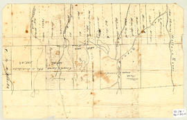
Topographic map of East Folly Mountain area showing Wallace River, East Branch River, Pines Brook, Totten Brook, divided lots with owner names including Fleming, McLain, Slack, Forsyth, Patten, Crowell, Barnhill, Archibald, Duncan, McNutt and Faulkner. Drawn November 1868 by unknown person. 92.246.1
Map shows Truro Township along the Salmon River, including the first main roads of the Town. Includes grantee lots and owner names with inset of Birch Island in Upper Village. 93.40.1a
An original hand drawn map of the New Marsh, Lower Village (aka: Lower Truro, Colchester County, NS), showing numbered lots of land with owner names and acreage. Shows New Dyke Road, Soley's Creek, Cobequid Bay, Savage's Island and existing marsh area. Whole area = 51 ac, 2 qrs, 38 rods. Surveyed by Edmund Archibald, Land Surveyor, August 14, 1901. 2005.41.1
Original hand drawn map of A Plan of Lands in Folly Village, surveyed by Donald Urquhart, Dep. Sur., January 9, 1850.Shows Colchester County land lots, owner names and directional measurements. Note: Map 2011.62.8 is very similar but has a few different names on the lots. Both maps were apparently done the same day by the same person. 2011.62.9
Original hand drawn map which shows the property boundaries of land to be divided between 4 sons - James, William, Wilson and John Staples - heirs of William Staples Sr. of Onslow, NS., 1871.Edward Higgins, Thomas Chisholm and Alexander Barnhill state and witness that they were asked to divide the land between the 4 sons (presumably to settle an estate). 2011.81.1
1 original hand drawn map showing new proposed road as continuation of Gunn's Road, connecting from West Branch Road to River John Road and the properties it will cross (McKay, Munroe, McBain and Langille's). Surveyed by Gilbert Sutherland Feb. 11, 1884.Confirmed - May Session, 1884. Recorded in Road Bank pgs 476-9. 2019.45.1
Map showing the lands of Rev. Hugh Ross and Campbell McDonald, as well as portions of the French River, Waugh's River and the Road to Wallace. Part of the DesBarres Grant in Tatamagouche area. 1999.94.1a
Original hand drawn map attached to land grant of Abraham Patterson. Shows Tatamagouche River, water lots and owner names, including adjoining lots. 1999.94.1c