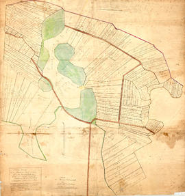
Original map showing Masstown Marsh including roads, waterways and granted lots with grantee names and acreages.Coloured: green indicates upland and islands, yellow indicates drains, creeks and ponds, brown indicates roads, red indicates dykes.Made by Thos. Miller, Surveyor, on July 25, 1863. Copy made for made for James Campbell by A. W. McLelan on September 12, 1863. 92.358.28
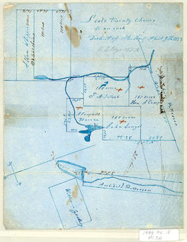
Original hand drawn map showing plan of lots in the District of Sterling, Colchester County, NS. Surnames include Patterson, Campbell, McIntosh, Langel, Whippie and Geddes. Surveyed by Robert L. Byers, April 9, 1857. 1999.94.18
Original hand drawn map showing lots of property owners: Patterson, Patriquin, Wm. Bell, and others. Includes French River and Road to New Annan and Tatamagouche. 1999.94.42
Original hand drawn map showing plan of lots including A. Patterson's and several other names, showing both old and new Road from Truro to Tatamagouche, NS. 1999.94.31
Original hand drawn map of the lots of the west side of Waugh's River. Surnames on lots include Purves, Campbell, McDowal, Brydon, Patterson, Waugh, Young. Surveyed by John Gauld, Deputy Surveyor, River John, January 1848. 1999.94.3
Copy of a map by John Gauld (made by A. M. Macnab, P. D. Surveyor). Unknown date.Shows plan of lots on the west side of Waugh's River, Main Rd. from Pictou to Amherst, New Annan Rd., Property Lots of Patterson, Campbell, Young, McDowal. McDonald, Brydon, Waugh. Also shows the edge of the Tatamagouche River. 1999.94.39
Original hand drawn map showing Line of Road to William Bell's lot. Includes grantee surnames: Patterson, McDonald, Campbell. Shows Main Road to Tatamagouche and West to New Annan. No date or surveyor given. 1999.94.27
Original hand drawn map showing roads from Truro to Tatamagouche, both old and new. Also includes road to Farm Lake, Farm Lake, Whippy Lake, Black Lake, lots of surnames: Patterson, King, McKeen, Kennedy and others. 1999.94.41
Original hand drawn map showing west side of Waugh's River, high water mark, properties of heirs of late William Campbell Esq.. Also shows Main Road through Tatamagouche and other town lots. 1999.94.29
Original hand drawn map showing Lot No. 27 of the DesBarres Grant and west side of Tatamagouche River. Specifically highlights portion of land conveyed to G. Tattrie (in red ink) with written description beside drawing. Enlarged area from Plan of DesBarres Grant. 1999.94.43