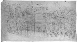
A plan of the settlement of River John and vicinity shows the area from Seafoam to Tatamagouche, including land grants and owner names as well as many details and waterways. 2017.32.1
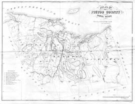
Map showing Pictou County mining areas including Nova Scotia Coal Co., Acadia Coal Co., Intercolonial Coal Mining Co., Halifax Company, Montreal & Pictou Co., East River Coal Co., Montreal & New Glasgow Coal Co., Pictou Mining Co., Vale Coal Iron & Mfg Co., and Mitchell & Barton's area. Undated, but research revealed Montreal & New Glasgow Colliery opened at Coal Brook and operated for one year only - 1868, therefore its inclusion on this map seems to date it closely to this time period. See novascotia.ca/archives/meninmines/timeline. Drawn by George Hattie, Land Surveyor. Printed by Barlan Desbarats Litho. Company, Montreal. 2019.5.1