A reproduction map of Atlantic Canada showing a list of wreck sites and their locations. Showing coastal towns, cities, provinces, main waterways, inset of Halifax Harbour. Published by the hydrographic and Map Service, Survey`s and Engineering Branch, Dept, of Mines and Resources, Ottawa. First Edition 1943, New edition Dec. 15, 1944. 2007.89.1
One black and white reproduction map created by D. D. Currie of Moncton in 1889. Shows hand illustrated streets, homes and large buildings throughout the Town of Truro and includes detailed labelled drawings of major businesses around the outer edge of the map. 94.137.1
A 1911 newsprint reproduction of an 1837 map of Truro NS. Shows homeowner names and buildings, businesses, main roads, Salmon River, Mill Race and Boyd's Brook. 88.92
Street map of 1878 Truro and Bible Hill including names on many properties and a separate list of names and businesses identified. Shows railway, buildings and Salmon River. Very detailed and could be a mate to the A. F. Church Co. map series, but this is not confirmed. Appears very similar. 88.20
Truro Township map showing grantees and lots as drawn by Thomas Harris in 1788.This is a "true copy" of the original as stated on the map. 2013.60.4a+b
Color reproduction map of the Town of Pictou, NS, 1878. Published by J. H. Meachan & Co, and C. R. Allen (surveyor). Was originally folded and likely accompanied an Atlas Book of Pictou County. Shows Town of Pictou including 1st, 2nd and 3rd Wards, streets, buildings, lots and owner names, Pictou Harbour and wharves plus many other details. 2007.25.7
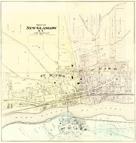
Color reproduction map of the Town of New Glasgow, NS, 1878. Published by J. H. Meachan & Co, and C. R. Allen (surveyor). Was originally folded and likely accompanied an Atlas Book of Pictou County. Shows Town of New Glasgow including 1st, 2nd and 3rd Wards, streets, buildings, lots and owner names, East River of Pictou and many other details. 2007.25.7a
Item is a map published during World War 1 by the Montreal Star Publishing Company Ltd, titled "The Canadians in France." The map indicates locations where Canadian troops distinguished themselves. Map 185