Maps

Elements area

Taxonomy

Code

Scope note(s)

    Source note(s)

      Display note(s)

        Hierarchical terms

        Maps

          Equivalent terms

          Maps

            Associated terms

            Maps

              162 Archival description results for Maps

              162 results directly related Exclude narrower terms
              France
              Item
              Item is a map of France, created through an ordnance survey. Map 207
              Item · 1938
              This history is a discrete item and was written by Clare Palmer in 1938 when she was about thirteen years old. It was likely part of a school assignment as there appears to be a comment written by the teacher on the last page. In his or her comment the teacher praises the value of the information provided by Clare and suggests that she donate it to the public archives. This handwritten, handmade history book is based on information provided by Mr. George Marks, Mrs. Bruce Marks, and Mr. and Mrs. E. A. Marks, whose contribution is acknowledged by Clare at the outset of her work. Her history includes chapters on the first settlers, the growth of the settlement, Ship Harbour industries, schools, transportation, churches, food, clothing, and lights; amusements, public buildings, prominent people, nature, and a final chapter that discusses Nichol Island and Wolfe Point as well as the origin of the name “Ship Harbour.” The book includes three hand drawn maps: one of Ship Harbour that features dwellings, G. L Monk’s store and mill, the J. L. factory, and the chapel; a second map depicting early roads in the area in 1863 as well as a ferry; and one small map of Nichol Island. The second last page also includes a photograph of the lighthouse at Wolfe Point on Nichol Island, which is were Clare lived with her family in the lightkeeper’s house. The book also includes two newspaper clippings, one about Daniel Weeks and one about the 50th anniversary of Mr. and Mrs. Edward Addington Marks which includes a picture. Accession number: 2013.013
              Financial records
              Series · 1834
              Part of F. Mitchell, Hosking family fonds
              Series forms part of F. Mitchell, Hosking family fonds and consists of personal receipts, invoices, bills, lists of expenditures, and policies mostly belonging to the Hosking and Mitchell families, as well as one receipt from the store of G. L. Monk in Ship Harbour for lumber. Series also includes one land grant, two land indentures, two maps and one bill of sale.The land grant is dated August 12, 1834 and in it the Crown grants Colin Mitchell Sr. two hundred acres of land in Oyster Pond adjacent to a lot of land granted to Edward Hare. The document discusses the boundaries of the property and includes a map of the Oyster Pond area, clearly showing Colin Mitchell’s land grant as well as that of Edward Hares, and land near Navy Pool surveyed for W. Myers. The land grant is signed by Lieutenant Governor, Major General Sir Colin Campbell. The second map in the series is of a land grant map of Halifax County from the Department of Lands and Forests dated 1932.The land indentures include one transaction between Samuel Mitchell and John D. Mitchell dated April 7, 1873. In it, Samuel Mitchell gives John D. Mitchell a parcel of land at the head of Jeddore harbour, in the area of Oyster Pond, for the sum of forty dollars. The document is witnessed by Timothy Archibald John Cribby. The second indenture is between Hibbert, Lord Bishop of Nova Scotia, and Archibald Prest and dated 1883. In the indenture, Prest buys a parcel of land in Mooseland for the sum of one hundred and fifty dollars. The bill of sale is dated November 25, 1874 and transfers sixty-four shares in the ship P.C. Hill to John Mitchell. Series also includes records regarding the settlement of the estate and outstanding debts of the late Philip Mitchell. The estate was settled by his nephew, John Duncan Mitchell. Accession numbers 2003.011, 2010.013
              E.J. Webber fonds
              Fonds · 1941-1945, 1951-1955
              Fonds consists of records related to the activities of E. J. Webber during his time spent serving with the 2nd Reserve Battalion Halifax Rifles in World War II and his shared activities with his wife Babe Webber in her role as postmistress in Lake Charlotte during the 1950s. Records were created between 1941 and 1945, and between 1951 and 1955. Fonds has been arranged into the following two series: S1- 2nd Reserve Battalion Halifax Rifles S2- Lake Charlotte Post Mistress Accession number 2009.045
              Series · 1941-1945, predominant 1942-1944
              Part of E.J. Webber fonds
              Series forms part of the E.J. Webber fonds and consists of records related to Webber’s activities as a 2nd Lieutenant in the 2nd Reserve Battalion Halifax Rifles during World War II. Series includes documents related to Webber’s training as an officer, as well as instructions on training others including booklets, manuals, memorandums, notes, an examination sheet, and other material. This includes copies of the Canadian Army Training Memorandum, which was a series of pamphlets published on a monthly basis from 1941 to 1945 which were intended to be distributed among all Canadian officers who were serving domestically. The memorandums featured articles and information on various aspects of military life and training. Series also includes issues of War and Current Affairs, a series of booklets issued by the British Army Bureau of Current Affairs; issues of Canadian Affairs, a series of booklets issued by the Canadian Wartime Information Board; and an issue of The Maple Leaf, a newspaper issued to Canadian soldiers. Also included in the series are forms and correspondence related to travelling expense claims for bus trips to Sheet Harbour for officer training classes and for trips to Musquodoboit Harbour and Ship Harbour to supervise training detachments. In addition, series includes a certificate authorizing Webber to be an official Royal Canadian Air Force Aircraft Detection Corps observer, an instruction sheet issued by a superior officer, forms, maps, a postcard, and other material. 2009.045
              Series · [ca. 1965]-2003
              Part of Robert M. Ritcey fonds
              Series forms part of the Robert M. Ritcey fonds and consists of the contents of two binders, each comprising volumes of a work entitled “Memories and family: collections by Robert M. Ritcey” (also entitled “Memories, family, and collections of Robert Milton Ritcey Sr.”). The work is a collection of research material related to the Ritcey family of Nova Scotia, as well as other families connected to the Ritceys, including the Newman, Williams, Bayers, and Gaetz families. The work comprises material created by Ritcey or collected from other sources, and includes text; family trees; excerpts and transcriptions from publications; records such as certificates and forms; correspondence; maps; drawings; and other material. All of the material from the binders is photocopied, with occasional annotations in pencil. Included in the work are drafts of Ritcey’s memoirs “The Place” and “The People”. Also included in the work are colour copies of photographs of Martinique Beach and Dun’s Beach. Ritcey began collating the material in 1986, although he had begun creating some of it in 1972 or earlier, and had been accumulating it for many years before then. Series also includes a letter to the Lake Charlotte Area Heritage Society related to the upcoming publication of part of his work, along with an annotated copy of an introduction to be included in the publication, and a copy of a map of the area around Martinique Beach in around 1937, hand drawn by Ritcey. Accession number 2010.004
              Item · ca. 1960- 1980
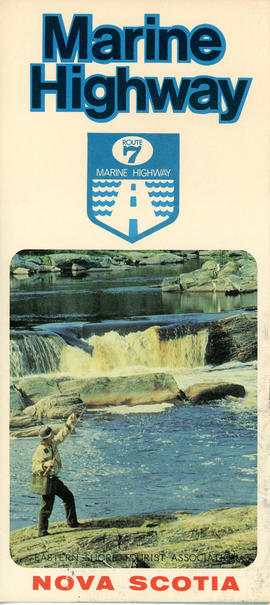
              This item is a brochure produced by the Eastern Shore Tourist Association, featuring information on the Route 7 Marine Highway, a scenic route that forms part of the Trunk 7 highway and stretches from Dartmouth to Canso, skirting the Atlantic coastline through seaside villages and farming communities, past beaches, museums and other points of interest. The item consists of a map and a brief description of the Eastern Shore including local and natural attractions, communities, and history. The brochure also includes several images of scenery and attractions that can be found along the way. Accession number: 2013.018
              Helene Read fonds
              Fonds · ca.1790-1996
              Consists of records related to the life, activities, and interests of Helene Read and includes family photographs, Stoddard family history and land information, personal and professional correspondence, information about the Nova Scotia Lifeguard Service and other organizations with which Helene was involved. Accession number 2013.019
              Land indentures, maps, wills
              Series · ca. 1760-1945
              Part of Helene Read fonds
              Series forms part of the Helene Read fonds and consists of a land indenture dated August 8, 1799 in which possession of land in Clam Harbour is passed from Robert, Colin, and Patrick Campbell and their wives to Thomas Stoddard. Series also includes information concerning other land grants in Clam Harbour belonging to the Campbell and Stoddard families between 1765 to 1894 and 1945. Four maps are also included in the series and include plans dated 1956 showing the division of the estate of James Stoddard as per his will, a map of the lands of Ralph Stoddard dated 1970, and two maps showing the subdivision of Lot 1 lands owned by Douglas F. Stoddard dated 1963. In addition there is one map of the land belonging to Robert Sr., Duncan, and Robert Campbell as well as two pages of microfilm copies of the land grant document presumably for that piece of land c. 1760. All maps pertain to land in Clam Harbour. Series also contains copies of the wills of James Edward Stoddard, Thomas Stoddard, Adam Stoddard, Edmund Fanning Stoddard, and documents concerning the estate of Nancy Stoddard. Accession number 2013.019
              Fonds · 1969-1995, predominant 1972-1983
              Fonds consists of records of the Association for Preservation of the Eastern Shore and its members. Records were created between 1969 and 1995, but predominantly between 1972 and 1983. Records in the fonds are arranged into the following series: S1- Ship Harbour National Park proposal S2- Community activism S3- Research material S4- Correspondence S5- Meeting minutes S6- Memorandums of association S7- Financial records S8- Photographs S9- Newspaper clippings Accession numbers 2009.035, 2009.036, 2013.019