Maps

Elements area

Taxonomy

Code

Scope note(s)

    Source note(s)

      Display note(s)

        Hierarchical terms

        Maps

          Equivalent terms

          Maps

            Associated terms

            Maps

              162 Archival description results for Maps

              162 results directly related Exclude narrower terms
              Fonds · 1834, 1873-[ca. 1975], [1995?]
              Fonds consists of records of the family of F. Mitchell and the related Hosking family of Nova Scotia and includes financial records, records related to the Murray Harbour Black and Silver Fox Ranching Company, photographs, diary excerpts, correspondence, certificates, records related to tourism, wartime and military memorabilia, religious records, records related to the Freemasons, and music. Accession numbers 2003.011, 2006.001, 2010.011, 2010.012 and 2010.013.
              Maps
              Series · [193?] - [194?]
              Part of H. Léander d'Entremont fonds
              Series forms part of H. Leander d'Entremont fonds and consists of 17 maps, including maps of the Pubnico area.
              Item · [after 1836]
              Original hand drawn map which shows the topographical junction point of Colchester, Halifax and Guysborough Counties. This is an early, undated map, but since Guysborough was officially named in 1836, we know this map to be later than this date, but likely no later than 1875. The map shows land grants and grantee names, waterways and roads. Of note is Windsor College marked on 5 acres. 2019.24.1
              Item · 1853 - 1867
              Original hand drawn map showing Tatamagouche and Area - DesBarres Grant lots and others. Showing county lines, lots, owners, waterways. Dates 1853 - 1867. Surveyed by George Hattie, Land Surveyor 2003.7.1
              Item · 1911
              Original 1911 reproduction of a Truro Street Map, including Business Directory and corresponding map locations in red print. Includes Truro population and town statistics.Printed by C. F. McAlpine, Halifax, NS. 1911. 88.9.d
              An original hand drawn map showing West Prince St. and Robie St. in Truro, NS, including property lots of Rettie, Cummings, Walker, Faulkner and Longworth. Acreage and lot dimensions included. Surveyed by William Faulkner, Oct. 16, 1880. 88.68
              Item · 1908
              Hand drawn map showing Prince St. West - building lots and some owner names including Leaman, Bowden, Paris, Ashe, Sheppard. Surveyed for Messrs L. & Rettie by J. K. Eaton, D. C. L. Surveyor on Oct. 3, 1908. 88.69
              Item · 1884
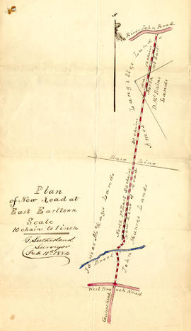
              1 original hand drawn map showing new proposed road as continuation of Gunn's Road, connecting from West Branch Road to River John Road and the properties it will cross (McKay, Munroe, McBain and Langille's). Surveyed by Gilbert Sutherland Feb. 11, 1884.Confirmed - May Session, 1884. Recorded in Road Bank pgs 476-9. 2019.45.1
              Item · 1850
              Original hand drawn map of "Follie Village, surveyed by me this 9th day of January 1850" by Donald Urquhart. Shows Colchester County land lots, owner names and directional measurements. Note: Map 2011.62.9 is very similar but has a few different names on the lots. Both maps were apparently done the same day by the same person. This map states, "This plan belongs to J. A. Fraser 2011.62.8
              Item · 1850
              Original hand drawn map of A Plan of Lands in Folly Village, surveyed by Donald Urquhart, Dep. Sur., January 9, 1850.Shows Colchester County land lots, owner names and directional measurements. Note: Map 2011.62.8 is very similar but has a few different names on the lots. Both maps were apparently done the same day by the same person. 2011.62.9