River John (N.S.)

Elements area

Taxonomy

Code

Scope note(s)

    Source note(s)

      Display note(s)

        Hierarchical terms

        River John (N.S.)

          Equivalent terms

          River John (N.S.)

            Associated terms

            River John (N.S.)

              2 Archival description results for River John (N.S.)

              2 results directly related Exclude narrower terms
              Maps
              Series · [ca. 1935-1965]
              Part of Annabel (Siteman) Ells fonds
              Series forms part of the Annabel (Sitman) Ells fonds and consists of several maps, the majority of which were produced by the Department of Mines and Resources between 1935 and 1948 and include the areas of Yarmouth, Shelburne, Queens, and Annapolis counties, Tangier, Upper Musquodoboit, Ship Harbour, Guysborough County, Ecum Secum, Moncton, Cape Breton, Owl’s Head, Port Dufferin, River John, New Glasgow, Halifax. Series also includes highway and tourist maps of Nova Scotia, the Maritimes, Halifax and Dartmouth from c. 1948-1965 as well as street guides of Halifax and Dartmouth c. 1955-1965. Also included are Department of National Defence topographical maps of Chezzetcook, Musquodoboit, Halifax, and Sambro from 1939 and 1943. Accession number: 2013.066
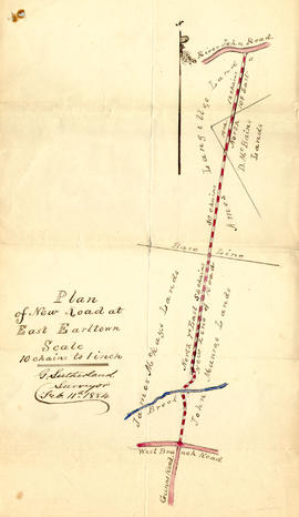
              Item · 1884
              1 original hand drawn map showing new proposed road as continuation of Gunn's Road, connecting from West Branch Road to River John Road and the properties it will cross (McKay, Munroe, McBain and Langille's). Surveyed by Gilbert Sutherland Feb. 11, 1884.Confirmed - May Session, 1884. Recorded in Road Bank pgs 476-9. 2019.45.1