Roads

Elements area

Taxonomy

Code

Scope note(s)

    Source note(s)

      Display note(s)

        Hierarchical terms

        Roads

          Equivalent terms

          Roads

            Associated terms

            Roads

              14 Archival description results for Roads

              14 results directly related Exclude narrower terms
              Item · 1884
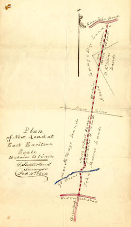
              1 original hand drawn map showing new proposed road as continuation of Gunn's Road, connecting from West Branch Road to River John Road and the properties it will cross (McKay, Munroe, McBain and Langille's). Surveyed by Gilbert Sutherland Feb. 11, 1884.Confirmed - May Session, 1884. Recorded in Road Bank pgs 476-9. 2019.45.1
              Research material
              Series · [ca. 1920], [ca. 1967]
              Part of W. Hugh Conrod fonds
              Series forms part of W. Hugh Conrod fonds and consists of records likely related to research undertaken by Conrod on the road now known as Nova Scotia Highway 7. The research was likely related to a display of photographs which Conrod put on at the Dartmouth Heritage Museum circa 1967. The photographs were possibly taken along the Highway 7 route. Series includes a copy of the Nova Scotia Highways Statutes of 1920, a photocopied excerpt from James E. Rutledge’s 1954 book “Sheet Harbour: A Local History,” and a sheet of typewritten notes referring to a stage coach route. 2010.005
              W. Hugh Conrod fonds
              Fonds · [ca. 1920], [193-?], [ca. 1967]
              Fonds consists of material created and/or accumulated by W. Hugh Conrod. Material was created around 1920, probably in the 1930s, and around 1967. Fonds is arranged into two series: photographs, and research material. Accession number 2010.005.