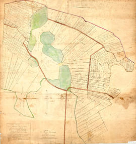
Masstown (Colchester County N.S)

Elements area

Taxonomy

Code

Scope note(s)

    Source note(s)

      Display note(s)

        Hierarchical terms

        Masstown (Colchester County N.S)

          Equivalent terms

          Masstown (Colchester County N.S)

            Associated terms

            Masstown (Colchester County N.S)

              3 Archival description results for Masstown (Colchester County N.S)

              3 results directly related Exclude narrower terms
              Series · 1901-1965 (missing: 1906-1907, 1908-1921, 1925-1927)
              Part of Colchester County School Registers fonds
              Series forms part of the Colchester County school registers fonds and consists of 69 school registers for Masstown School, from 1901-1965 (missing: 1906-1907, 1908-1921, 1925-1927). Most registers measure 28x44cm or 26x38cm and contain 10-20 pages, though in some cases, only a few pages remain. Registers generally include a list of students' names, along with their sex, age, address, parent or guardians' names, as well as a record of attendance and general standing. Registers have been printed by the Nova Scotia Department of Education and data has been handwritten by the schoolteacher. 2010.135.1 - 2010.135.6, 2023.1.4756 - 2023.1.4818
              Series · 1965-1974
              Part of Colchester County School Registers fonds
              Series forms part of the Colchester County school registers fonds and consists of 69 school registers for Chiganois Elementary School in Masstown, from 1965-1974. Most registers measure 28x44cm or 26x38cm and contain 10-20 pages, though in some cases, only a few pages remain. Registers generally include a list of students' names, along with their sex, age, address, parent or guardians' names, as well as a record of attendance and general standing. Registers have been printed by the Nova Scotia Department of Education and data has been handwritten by the schoolteacher. 2023.1.4819 - 2023.1.4887
              Plan of Masstown Marsh, 1863
              Item · 1863
              Original map showing Masstown Marsh including roads, waterways and granted lots with grantee names and acreages.Coloured: green indicates upland and islands, yellow indicates drains, creeks and ponds, brown indicates roads, red indicates dykes.Made by Thos. Miller, Surveyor, on July 25, 1863. Copy made for made for James Campbell by A. W. McLelan on September 12, 1863. 92.358.28